|
|
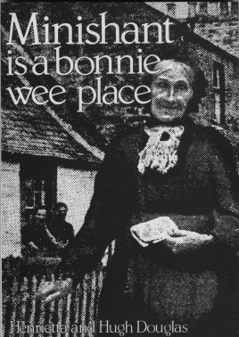
Minishant is a bonnie wee place. Portrait of a Village by Henrietta and Hugh Douglas. Line drawings by Michael Ellis. Strathprint, 146 Broadway Peterborough. First Published 1982. Copyright © Permission for display on this site granted by Hugh Douglas. You may view and download chapters of this book for personal research purposes only. No other distribution of this text is authorized. Click here for other books by Hugh Douglas. Cover: Mrs. Margaret Limond, was Minishant postmistress until she died aged 94. |
Hugh Douglas
When change came towards the end of the 18th Century it was sudden and dramatic, and it embraced farming, industry and communications. First, and perhaps most important, were the new roads, most of which in South Ayrshire resulted from the Second Ayrshire Turnpike Act of 1774.
Up to then, roads in Ayrshire had been notoriously bad -so bad in fact that in the 16th Century the King was so buffeted on a journey through the county that he threatened to sent the next man against whom he bore a grudge to attend a wedding at Sorn. Burns also complained in verse after a journey between Kilmarnock and Stewarton:
I'm
now arrived, thanks to the gods!
Thro'pathways rough and muddy -
A certain sign that making roads
Is not this people's study.
And tho'I'm not with scripture crammed,
I'm sure the bible says
That heedless sinners shall be damned
Unless they mend their ways.
Better times lay ahead, and it was appropriate that Monklands should benefit from the general upsurge in building at the end of the 18th Century since it was here that John Loudon Macadam experimented with his method which was to become the standard way of making the roads which transformed the face of Britain. Macadam was born in Ayr in 1756 and was taken to New York in 1760, but in 1783 he returned to Scotland and bought Sauchrie estate. During his 13 years there Macadam was a member of the Ayrshire Turnpike Trustees and spent much time experimenting with new methods of road-building. At Sauchrie he laid down the first stretch of "macadmised" road, and by the time he moved from Sauchrie in 1796 to live in England, he left behind in his native Ayrshire a network of good roads. One road not completed by the time he left, although it was already planned, ran from Ayr to Maybole by a far easier route than the old High Road along Brown Carrick foothills. This road followed a route by Corton and Doonhoim, then along the valley of the river Doon past Blairston House (Nether Auchendrane) and across the river by a bridge near the Auchendrane ruin and over the Polnatibber burn where Minishant now stands, before continuing by Kewnston and Smithston to Maybole. The road was completed in 1798, with tollhouses at Carcluie where a branch to Dalrymple turned off, and Mossend (later Hogg's Corner) at the junction of the Kirkmichael road. The Doon bridge at Blackhill bears the date 1798.
A network of small roads quickly spread out from this new Low Road as can be seen from Thomson's map of Ayrshire, made in 1828 for his Atlas of Scotland. The new road was needed because trade and farming were expanding. There were few names on the Armstrong map of 1775 other than the old Kennedy forts of Craigskean, Knockdon, Garryhorn and Brockloch. Pinmore and Milburn (High Milton) were there and in the Minishant area Whitelees, Mains (probably Brae), Midton and Milton.
By the time Thomson made his map the face of Ayrshire had changed. Much of the land had been drained, new woodlands planted and farms set out with small patchwork fields enclosed by beech and thorn hedges. New names had been added on the High Road since Armstrong's day, Breek, Meadownay, High Grange, East Mid and West Brockloch, Glenbay, Woodhouse, Greenholme, Glenhead and Laigh Grange. At Minishant (still named Cuiroy) now could be found Monkwood Mains, Colquhounston (Kewnston), Blackhill, Crorishill, Burnmouth, Laigh Woodston and some other names which have since vanished - Bar, Hillend and Millhill.
The Rev. George Gray in compiling the 1837 New Statistical Account commented "The fields are now well enclosed and drained, and bear abundantly all kinds of agricultural produce".
Minishant district had neither the coal nor iron which began to change the face of Ayrshire at the close of the 18th Century, but it did have one useful raw material - the fast-flowing Polnatibber burn to provide power to drive a mill wheel. Cotton-spinning became the great thing in Ayrshire, and old grain mills and other buildings were being turned into cotton-spinning factories. Round about 1800 a family named Limond moved in to set up a wauk mill to spin wool and weave cloth, although whether it was a new building or conversion of an older one is not clear. Limond's mill was beside the new bridge which carried the Low Road across the burn and it was on the work of this mill that the village began to grow. The mill still stands, used as the village hall. There was already a building here when the Limonds arrived, the place marked Culroy on the Armstrongs' map, and the house now named Glenisla is known to have been built on the site of two cottages dated 1799. Others followed quickly so that within a remarkably short time the village grew to the size it remained until the 1930s. Its population must have risen quickly to about 80 people, and it was no longer a remote or isolated place.
Dozens of carriers' carts passed through on the way between Ayr and Maybole, Kirkmichael, Straiton, Newton Stewart, Crosshill and Dailly and Girvan, and on Ayr market days a covered cart ran for passengers. Generally these carters were a rapacious lot and their greed was given as one of the reasons for supporting the building of railways later on.
The royal mail coach called three times a week on the journey between Glasgow and Port Patrick, then the seaport for Ireland. In 1832, by which time Stranraer harbour had opened, a coach, the Erin Go Bragh called at the village every Tuesday, Thursday and Saturday on its way south. Two other coaches, the Robert Burns and Earl of Cassillis called on Tuesday (market day in Ayr) and Friday mornings on the way from Girvan to Ayr and again the same evening on the return journey.
The three principal estates of the district changed owner-ship too. Sauchrie passed to Archibald Kelso and Alexander Hamilton took over Grange, while Monkwood was bought for a family named Paterson. William Paterson, a lawyer in Jamaica, left instructions in his will that two estates should be bought in Scotland for his heirs. One was Monkwood, the other Ladykirk at Monkton. Monkwood came to a nephew, another William Paterson who never lived in the house but let it. I have heard a story told in our family (but have not been able to confirm it) that one of these tenants, a man named Taylor, walked out of the house one morning, leaving his cup and saucer on the breakfast table and didn't return for 20 years. Could this have been around 1840 when the Directory of Gentlemen's Seats, Villages &c in Scotland (published 1843) reported Monkwood unoccupied? James Paterson who wrote a history of the County of Ayr between 1847 and 1852, lived in Monkwood and it was probably he who changed the name of Monkwood to Paterson House around the middle of the 19th Century. Monkwood was called Paterson House in the 1860 Ordnance Survey map, but soon after it reverted to its old name.
The Ayrshire Directory for 1830 contained an entry, "Monkwood Grove is an excellent garden about five miles from Ayr, and Mr. Goudie is extremely civil to all sorts of strangers". Monkwood Grove, a remote corner of Monk-wood estate beside the river Doon, was later tenanted by James Smith who became a world famous botanist consulted by eminent botanists, including Sir William Hooker, who used much material collected by Smith.
Smith gathered rare plants from many places to create what was one of the prettiest gardens in Scotland. He loved his plants so much that he couldn't bear to destroy any of them and it is said that once when he was compelled to chop down a tree which had grown so large that its shadow threatened other plants, he shut his eyes and hacked at the tree until it fell. I wonder if he was responsible for grafting an ash on to a beech tree to make the huge tree, half beech half ash, still to be seen at the Laigh Hill Field gate on Monkwood Mains ground? Perhaps not, since the Armstrongs have marked on their map at Auchendrane "a curious ash tree".
Smith died on 1st January 1848, aged 88 and on his tombstone in Ayr Auld Kirkyard he is described as "the father of Scottish botany".
By the end of the century both the house and garden at Monkwood Grove had gone but it remained a favourite place for Sunday afternoon walks and occasionally we were rewarded with a sight of one of Smith's rare flowers surviving among the tangle of brambles and wild plants. Monkwood Grove was so remote that a little house which stood on the Dalrymple bank of the river was known as Fin' Me Oot. Although Fin' Me Oot cottage has gone too, the two fields on Monkwood Mains land beside the river are known as the Fin' Me Oot holms.
Auchendrane lands passed to the Fergussons of Kilkerran and later to Elias Cathcart of Blairston, or Nether Auchendrane as it was re-named. In 1839 James Ferguson bought the estate with the intention of building a new house on the site of the ruined castle. However, this was only carried out by J. Fairfull Smith in 1856.
The whole district prospered throughout the first half of the century, so that the Rev. George Gray was able to say in his 1837 Statistical Account, "The fields are now well enclosed and drained, and bear abundantly all kinds of agricultural produce". By 1837 this place which didn't have even a road 40 years before now was important enough to be included in Pigot's National Commercial Directory, with its gentry listed as James Ballantine of Blairston, John Ferguson of Monkwood, Archibald Kelso of Sauchrie, James Rankine of Beoch, James Rankine M.D. of Otterden and John Rankine of Knockdon.
The village by now had grown sufficiently to have a subscription lending library. It also had a schoolmaster, John McCaig, although it is not clear whether the schoolroom had been built at Burnside by then or not, and there were two shopkeepers, James Templeton and Gilbert Wilson (also a stonemason), and two vintners, William Cunningham of the Coach and Horses and John Lamont. The wauk mill was owned by James Lamont (Limond) and there was a tailor (James Aird), blacksmith (Alexander Heterick), two carpenters (John Gardner and James Jamieson) and two boot and shoemakers (Adam Gibson and David Wilson).
Culroy Bridge had its own blacksmith, joiner and public house, and at Auchendrane, close to the old castle ruin, a young man called Alexander Jack had established a small sawmill with capital of £10, where he quickly built up a thriving business making masons' mallets. In 1852 he sold up at Auchendrane and moved to Maybole, where a large number of out-of-work weavers were available for employment. Jack started to manufacture farm carts in a small way, but his business soon flourished and he was supplying all kinds of farm implements. Jack died in 1877 but the business continued in the town right up to the middle of the present century. John and James Gardiner took over the sawmill at Auchendrane and they too made farm carts, but in time the sawmill was closed.
Only two elements were now missing - the post and the railway - and both came in due course.
First to arrive was the postal service and this may be linked with the change of name from Culroy to Minishant. In the late 1830s the Maybole Penny Post was established and by 1841 the village was considered important enough for a receiving office to be opened to collect mail to be taken to Maybole. Nine years on, in February 1850, Culroy's own postmark was produced, but only two and a half years later in October 1852, a little rectangular stamp appeared with the name "Minishant", the first time the name was ever used so far as I have been able to discover.
Why did this change take place? I believe, but have no proof for this theory, that it was done to avoid confusion over the three Culroy names in current use - Culroy for Minishant village, and Culroy Bridge and Culroy Smithy for the present day Culroy. If my theory is right, this solves only half of the riddle. It made sense to change the name but why change it to Minishant? There is no earlier record of the name so one must assume that someone remembered the old story of the shrine or church and thought the name appropriate. But even that doesn't explain why it turned out to be Gaelic.
Could it be that John Brackenridge, a Maybole-born veteran of the 74th Highland Regiment, who became Minishant's first postman at the same time, had picked up Gaelic from his fellow soldiers, and had enough romance in his soul to translate the legend into a believable name? In the absence of other evidence, I like to think that is how Minishant came about.
The newly established post office was run by William Limond and his wife Margaret, and for 22 years until he retired in 1874, Johnnie Brackenridge delivered and collected letters to their post office which was only a corner of their kitchen in the cottage at the end of Monkwood Mains road.
The legend of how the Limonds came to have the post office has a flash of romance to it too. It is said that one day, while Mrs. Limond was baking, a knock came to the door and on the doorstep was a well dressed gentleman who asked if there was some place in the village where he could rest and have a cup of tea. She invited him in and gave him tea and scones straight from the girdle. He thanked her and left, and a few days later she received a letter from him asking her to become postmistress. The letter was signed Rowland Hill, for she hadn't realised that her visitor was the Postmaster General.
William Limond remained postmaster until his death in 1872, but his wife continued to run Minishant Post Office until her death on 17th February 1910, at the age of 94 years and 10 months. She was the oldest postmistress in Britain at the time of her death.
The railway came in the mid-1850s after much delay and discussion. Ever since the railway from Glasgow to Ayr opened in October 1840, there had been plans to extend it to Stranraer to capture the Irish trade, but there was dispute as to whether it should run directly south by Maybole and Girvan or be built as a continuation of the Dalmellington line through Galloway.
In 1846 an Act was passed for a line to Girvan with a branch to Maybole but this plan fell through and a less ambitious Ayr and Maybole Railway was planned some years later and and Act obtained in July 1854. Building started in November the same year for the line from Dalrymple where the Dalmellington railway branched off, along the river Doon past Fin' Me Oot to a point near Monkwood Mill where it crossed the river and turned away towards Smithston, Nether Culzean and Maybole. There was to be a station about a mile from Minishant on the Kirkmichael branch road, conveniently situated for the Kennedy house at Cassillis and named after it. The line was opened for goods traffic on 15th September 1856 and for passengers on 13th October 1857: it was worked by the Glasgow and South Western Railway who took it over in 1871. Cassillis was no more than a halt until additional buildings and a stationmaster's house were added 20 years later. Cassillis Villa was also built for shooting party guests arriving at Cassillis by train. The Ayr and Maybole directors were canny people - their line yielded between four and six-and-three-quarters percent when they ran it themselves but the G. & S.W.R. agreement gave them a fixed rent for their line which would yield a perpetual dividend of seven percent. For years afterwards they met regularly to declare their statutory dividend of seven percent and transact no other business. Surely they were one of the most fortunate railway companies in the country.
Minishant folk were not among the fortunate recipients of the regular seven percent dividends from the new railway, but they did benefit. They now had a railway station only a mile away giving the wauk mill access to markets much further afield. The village which was traced out on the 1860 Ordnance Survey map was a very satisfied place. Life may still have been hard, but it was secure.