|
by John Smith of Dalry (1895) - covering the Parishes of North Carrick Maybole │ Dalrymple │ Kirkmichael │ Straiton │ Kirkoswald │ Dailly (Transcription contributed by David Killicoat) |
|
|
|
Maybole, from its number of old castles, its camps and forts, its standing stones, and from the number of ancient relics that have been found from time to time - although in the matter of relics it cannot cope with either Stevenston or Dundonald - might well be called the antiquarian district of Ayrshire.
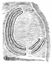
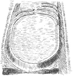
At the east end of Bowerhill, low down, situated on the left bank of a little stream, there are the remains of a fort (Fig. 252). It is placed on a point of land which has been nicked off by a ditch, and measures 31 paces by 23, the said ditch being partly filled up; the centre of the platform described is occupied by another ditch, surrounding a sort of citadel, which measures 11 paces by 8, the long distance being in the direction of the long distance of the outside platform, which is north-west by west, and south-east by east. There is a good look-out from this fort on the Firth, and the low-lying lands of Kyle, Brown Carrick and the Heads of Ayr are visible from it. At the west end of Bowerhill, high up, and situated on what is known as the Heads of Ayr, there is a fort placed at the extreme point of the heads. If it was to be known by nothing else, the richness of the vegetation caused by human occupation might point it out; but it has been defended on the land-side by a broad ditch, which is still 7 feet deep, the other sides of the fort being very steep. Its surface slopes seawards, and measures 25 paces by 21. The view from it is magnificent, commanding nearly the whole of the Firth of Clyde, Arran, Ailsa, and the greater part of the coast of Cunninghame, Kyle, and Carrick.
Near Dunduff Castle there is a fort (probably the original Dun Duff, or Fort of Duff ), called in the district the Danes' Hill, from a tradition that the Danes fought here (Fig. 253). It is a rocky knoll, with a patch of protected drift on its south-west side, an incident which enables us to speak with certainty of its having been a fort, for it is only this part that has any visible alteration wrought on it. Had it happened to be steep all round, like Hourat Castle Hill, then we could only have surmised from its name of Dane's Hill, or Dun Duff, that it had been occupied as a fort. The south-west side of this fort is protected by a ditch, 7 paces wide at the bottom. Inside of the ditch there is a rampart, or murus, slightly curved, and 36 paces long. Its top is 8 feet above the bottom of the ditch. The outer rampart is also curved, and sub-parallel to the inner one; it is 8 feet above the ditch, and 7 feet 9 inches above the surface of the field outside. The surface of the fort inside the inner rampart is 37 paces by 52, being very irregular, and, except next the rampart, the sides are precipitous and rocky. As it is situated 450 feet above sea-level, on the slope of Brown Carrick Hill, the outlook from it on the Firth is splendid.
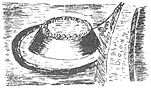
At the bend on the river Doon, a little-distance below the railway bridge, there is an old fort, named on the Ordnance map as ‘The Tower,’ but known in the district as ‘The Craig.’ The name ‘Tower’ is significant, and we might infer from it that The Tower near Dalry was also an old fort. This fort is 29 paces in diameter across its summit, being surrounded by the foundation of a wall or rampart, composed mostly of granite boulders, and thicker on the land-side than at any other part. The ditch on the land-side is wide, and the wall as it is is 14 feet above the bottom of the ditch, the slope on the river side being precipitous, and when in its complete state I have no doubt but that this old fort would have a tower-like appearance (Fig. 254). On Trees Hill there is a fort, and the place goes by the name of the Castle Knoll, its original name having been probably Dun Ean. On its south-west side there are the remains of three ramparts and three ditches. There are also the remains of a low wall on the north side, the diameter of the top of the fort being 24 paces and the ditch on the north side 12 feet 4 inches below the top of the earth wall. It has been very much altered, possibly by hunting for treasure. On its west side the rock has been quarried a bit, possibly in recent times. There were several tumuli in the district, now perhaps all removed, and two mounds were erected on West Enoch to commemorate the fight between Bargany and Cassilis, which took place in 1601. I was informed that these were levelled by the last tenant of the farm, and were probably the last remembrance mounds erected in Ayrshire. There was a cairn called Drumochreen, now probably all removed. On Kildon Hill there is a very fine fort, the space within the inner rampart measuring 54 paces by 25. Three sides of it - the south, east, and north - are rocky and precipitous, the east base of the rock showing an extensive scarp, which is carried round to the north side of the hill. On the west side the fort is defended by three ramparts and three ditches. The inner rampart is carried partly round the south side, is 43 paces in length, and is completely vitrified, being the only vitrified wall I have seen in Ayrshire, the height from the inside of the camp to the top of the vitrified wall being 13 feet 8 inches, and above the ditch at its highest part only 3 feet. The next rampart is about 12 paces, measured from centre to centre, outside of the vitrified rampart, and is only 15 paces in length, the hilltop here being narrow. Its top is 5 feet 6 inches above the last-named ditch, and 8 feet 6 inches above the next or middle one. The outside rampart is about 12 paces from the middle one, 5 feet 4 inches above the middle ditch, and 11 feet 4 inches above the outside ditch, which is partly cut out of the rock. The outside rampart is 36 paces long, and both it and the middle one are composed of earth, with a few stones. A recent footpath ascends the hill on its south side in a slanting direction, cutting through the vitrified rampart, and exposing a good section of it; the vitrification is also seen at three other places, the rest being covered with grass. The monument to Sir C. Ferguson is placed within the fort, and the outlook from it into the Girvan Valley is very fine. Near the Doon, and not far from its mouth, there is a Standing Stone of tough dolerite. In height it is 6 feet 8 inches above the ground, and at the base it measures 5 feet 10 inches by 3 feet. It is said to have been erected to commemorate a treaty of peace between the Picts and Scots. The field in which it stands is called the Stone Park, but the stone itself has no name. A short distance to the south-west of it, on Burton Farm, there is another Standing Stone, and tradition has it that there was a line of them all the way to Stranraer.
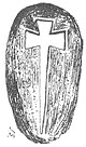
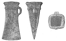
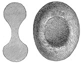
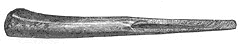
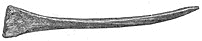
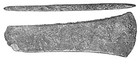
There is a granite boulder on Blairstone on which is cut an incised figure, popularly believed to represent the sword of Wallace; but a glance at it shows that it has not been made to represent a sword, but a cross, which measures 3 feet 6 inches long, and 14 inches over the arms of the cross, which, as well as the top of it, widen out a bit at the ends (Fig. 255). The tradition of the neighbourhood is to the effect that Wallace laid his sword on the granite boulder, and some kind artist chalked off the outline, and cut out its representation on the stone; but it is far too small for Wallace's sword, even if it were the proper shape. For its better preservation, the stone has been surrounded by a stone-and-lime wall, and some author says that the cross on it was cut to commemorate a treaty of peace between the Picts and Scots. On Newark Hill, where the people of the time assembled to have a look, from a safe distance, of the ships of the Spanish Armada, a flat stone was placed to commemorate the destruction of that formidable fleet; but it is strange that in the district there is no tradition about that stone, and some of the oldest inhabitants never even heard of the Spanish Armada, one of them gravely informing me that it had not been in the Clyde in his day. I searched the hill carefully, but could not find any trace of the stone. Perhaps it has been overgrown with peat. About 2 furlongs from the top of Newark Hill, towards the south-west, as I should have mentioned when speaking of the forts, the Ordnance surveyors show a ring camp, half a furlong in diameter; but after a lot of searching, I failed to find it. On Lyonstone there is a standing stone of gray granite, which stands 4 feet above the ground, and measures 3 feet 4 inches by 2 feet 7 inches. It is larger at the top, very much rounded at the angles, and is situated on the summit of a bit of rising ground. At Lochlands is a bit of land, once covered by the O Loch; there was found, in 1856, a fine hammer-axe of dolerite or whinstone. It is figured in the third volume of the Ayr and Wigton Collections, its size being about 8 inches in length, by 3¾ inches wide at the butt, and 2¾ inches thick, the sides being nearly parallel and straight. Its weight is 6 lb. 3 oz. On the lands of Lagg there was found an axe of greenstone, 10½ inches long, and a porphyry celt 4¾ inches long. On Dalduff, in an old crock in a drain, there was, in 1846, a hoard of bronze celts discovered; how many nobody knows. Three of them have been preserved in the National Museum at Edinburgh, with two portions of swords which covered the mouth of the crock; the rest are not at present known. The three are figured in the fourth volume of the Ayr and Wigton Collections, and belong to the looped and socketed types, with broad convex cutting-edges, one of them having two small apertures on the beading of the butt. One of them is 23/8 inches long, and the others 3¼ inches, the three being rather plain, with chamfered sides; the sockets are round or elliptical.
Another bronze looped and socketed celt was got in this district, and is figured in the fourth volume of the Ayr and Wigton Collections. The socket is sub-square, the chamfers slight, and on each face there are three slightly-raised ribs. It measures 3½ inches in length by 13/8 inches (Fig. 256). A bronze axe, 5 inches long by, 17/8 inches, was found at Auchendrane. A bronze dagger, 14¾ inches long, was dug up at Mosside. A bronze spear-head was got on Drumbeg. A bronze image of Justice, ‘with her equal scales,’ turned up at Drumshang. In the first volume of the Ayr and Wigton Collections a very much ornamented urn or ‘food vessel’ is figured, and is probably one that was found at the ‘fort.’ It measures 5¼ inches high, by the same in diameter at the mouth, and 2¾ inches wide at the base. Concerning it, Dr. Macdonald says: ‘The ornamentation of this "food vessel" is somewhat complicated and peculiar. The lip or upper edge of the mouth is scored with diagonal lines. Just below the rim come several encircling lines, indistinctly dotted as if with a finely-toothed instrument, and then a band so incised with triangular depressions as to have a zigzag form. At the line of greatest circumference is an encircling ridge scored with perpendicular markings; 1½ inches below is another, the space between being adorned in nearly the same way as the rather broader space between the first ridge and the mouth. Below the second ridge is a thin band with zigzag markings, between which and the bottom notched lines cross each other in diagonal fashion.’ The bottom of this specimen has got a star-like ornament. There are no court-hills in Carrick, and it is questionable if ever there were any. There is a natural eminence, called the Gallows Hill, 1 mile west of Maybole Castle. The castles of the district are Maybole, inhabited; Newark, inhabited; Greenan, Dunduff, an unfinished one; Dunure, Kilhenzie, inhabited; Doonside, Sauchrie, Craigskean, Beoch; Auchendrane, inhabited; Garryhorne, Brockloch, and Smithstone, which originally probably all belonged to the Kennedys or their dependents, Dunure having been their chief seat: ‘Twixt Wigton and the toon o' Ayr, Port Patrick and the
Cruives o' Cree, Seventy-one paces to the south-east of the oldest part of Greenan Castle there is a large ditch, the material from which has been spread on its north-west side. Nearer the castle there is another ditch, and it is quite probable that the castle site was at one time occupied by a more ancient fort. Near to the ruins of Dunure Castle there is an old dovecote still entire. Kirkbride Church, now a ruin, built in 1193 by the Earl of Carrick, is conjectured to have been a parish church. St. Cuthbert's, now rooted out, was also built by. the Earl of Carrick in 1193. The Collegiate Church, now a ruin, was built by Kennedy of Dunure in 1371. Lady Cross is near Brockloch. Of the named ancient wells, St. Helen's is to the north of Baloch Mount; Pennyglen Cross Well and St. Cuthbert’s in Maybole. In the grounds of Newark Castle there is still preserved the stump of the Dule Tree, on which culprits were hanged in baronial times. About 1830 there was turned up by the plough, near Dunduff Castle, a coin, about the size of a crown-piece, of Albert and Elizabeth of Bruges and Brabant. Maybole fairs occur at Candlemas, Beltan, Lammas, and Hallow. NOTE. - Since this was in type, I have discovered a shell-mound on the Carrick Shore, south of the Heads of Ayr. The great peculiarity about it is that under the mound there are eight seats hewn out of the solid sandstone rock, and capable of accommodating twenty-two persons. Six of the seats have curved backs, one is straight, and one projects. Many split bones were got, especially in the lower part of the mound, along with hand-made and wheel-turned pottery, bits of flint (none of them worked), copper, and iron. |
|
The Dalrymple district has been a pretty rich one in archaeological remains and relics, although the progress of agriculture has either obliterated or considerably modified the ancient structures, and no doubt many of the relics have either been lost or destroyed. In Barbiston Holm, during the making of a road in 1805, a mound - described by Mr. Fullarton, the proprietor, as a gravel hillock, was removed, and under it a stone coffin was found with human bones. Mr. Fullarton says, as narrated in the New Statistical Account of the parish, that he applied the end of the right thigh bone to his hip-joint, and the other end of it went nearly to the centre of his shin; and yet he informs us that he stood 5 feet 11 inches in height, so that in this mound a person of pretty lengthy proportions must have been buried. The big, or king's, cairns of the district are now all removed. One stood in Barbiston Holm, near to the mound described, one at Saint Valley, and one on Priest Hill. In them were got human bones, heads of pikes, spears, etc., which have probably all been lost. The Lindston Camp is situated pretty high up; the view from it is extensive, the Heads of Ayr and Brown Carrick Hill being well seen. This camp is circular, measuring round the outside of ditch, which is still filled with water, 192 paces in circumference. There is no rampart on the inside of the ditch, but on the outside of it there are slight remains of one. This arrangement is peculiar, and the outside rampart was probably intended as a screen to effectually blind the ditch; when the enemy, having got over the rampart, would find that he had a deep ditch to face, as well as the arrows of his enemies, who would be safe within the stockaded camp. On the east side there is a roadway across the ditch, and this, in all likelihood, was the entrance to the camp. The Woodland Camp is situated on the summit of rising ground, within a large loop of the Doon River. Here the Doon flows for 2 miles in a south direction, and, having reached Cassilis Castle, begins, to turn, and after a bit flows for 1½ miles through scenes of sylvan beauty, winding considerably as it goes. Within the loop thus formed the Woodland Camp stands. During recent years this camp has been ploughed over, but the ditch still forms quite a conspicuous feature on the land. The present farmer informed me that during ploughing operations he has repeatedly removed bits of a stone and lime structure placed along the inner side of the ditch. If this building (wall, I presume) has been contemporaneous with the camp, and formed part of it, then, so far as I know, it is a unique feature in connection with an ancient Ayrshire camp, and possibly points to a Roman origin for this camp, and, I may say, it is locally known as the Roman camp. We know that along the Roman Turf Wall, ‘Cespetitious Murus,’ between the Clyde and the Forth, the camps were furnished with stone and lime buildings. The reputed Roman road passes through this district, within 3 miles of this camp, and within 3 furlongs of the Lindston Camp. The writer of the New Statistical Account says that ‘on a ridge of a rising ground, about 3 miles in length, forming the boundary between the valley of Dalrymple and the low road from Ayr to Maybole, are the remains of three British fortlets. They are all circular, and surrounded by trenches, and contain about fifty falls of ground. The trenches were filled with a rich black mould, resembling moss-earth; and on its being removed some years ago for the purpose of manure, human skulls, bones, and deer's horns were found.’ No doubt this compost of human skulls, etc., would raise good crops. The Lindston and Woodlands camps appear to have been two of the fortlets referred to in the above quotation. Where the third one was situated I have not been able to ascertain. Two urns, or food vessels, were at one time dug up at Skeldon. Both are figured in the first volume of the Ayr and Wigton Collections, each being nearly 5 inches high, and nearly 3 inches wide at the base. One of them is ornamented all over the surface by perpendicular and diagonal lines, the spaces between which are filled in by triangular-shaped punctures. At 15/8 inches from the rim an incised line passes round it, below which it tapers to the base. The upper 1¾ inches of the other one is ornamented by eleven string-lines, placed in a concave belt, bordered below by a sharp incised groove, in which are placed four knobs. The tapering portion of the urn has got five incised lines marked with the herring-bone pattern. In 1790 a bronze tripod ewer was found in Lindston Loch. It is figured in the fourth volume of the Ayr and Wigton Collections, and measures 95/8 inches high, by 3¼ inches across the mouth, bulging out to 41/8 inches. It is furnished with spout and handle, and Dr. Macdonald, who describes it, says that, though they were long popularly believed to be of Roman manufacture, they are now known to be of late mediaeval origin. A bronze tripod ewer, with spout and handle, and almost identical to the Lindston Loch specimen, was found at Skeldon. At Percleman, in 1833, an earthenware jug was dug up. It stands 13 inches high, is 4¾ inches in diameter at the mouth, and 5¾ inches at the base, the greatest circumference being 26 inches. It is furnished with a handle and a small spout, and is variously ornamented, the principal figures being those of a man’s face and hands, and it was covered with a greenish glaze. It is figured in the first volume of the. Ayr and Wigton Collections. Dr. Macdonald, its describer, thinks it may have belonged to mediaeval times. This district contained the baronies of Dalrymple and part of Martnaham; the castles being Kerse and Barbiston (rooted out), and Skeldon (modernized and inhabited). A few silver coins have been found in this district, belonging to the reigns of James I of Scotland and Edward I and Edward III of England. |
|
Kirkmichael district is said to take its name from St. Michael, who lived during the tenth century.
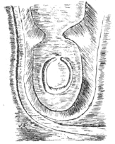
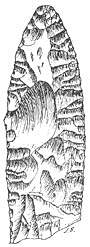
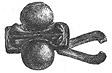
On Cassilis Downans, right over against Woodland Camp, there are the remains of a camp or fort. It occupies the summit of a small hill, on the south side of the river Doon, and near the farmhouse of Dunree. This fort is, in all likelihood, the original Dun Ree (Dun Righ), or King’s Fort. The top of the hill has been surrounded by a rampart of sods and stones, 152 paces in circumference, and the entrance has been by a gateway placed on the west side. From the vicinity of the Doon, and the hilly and undulating nature of the neighbourhood, this is a very romantic and charming spot, and one quite suited for the fort of a king. On Guiltree Hill, and situated between 500 and 600 feet above sea-level, there is another camp, but during recent years its site has been ploughed over; still, the ditch can be distinctly traced, and measures along its centre 224 paces in circumference. It is situated on the top of a small hillock, and from it there is a very extensive view to the north and south-west. There is said to have been another camp on Guiltree Hill, one on Kewnston, and one on Cassington, but I failed to find them, and they may have been entirely obliterated, as the country people did not seem to know anything about them. I have a perforated stone hammer axe which was got in this district under a cairn some sixty years ago. It measures 8¾ inches in length, by 4¼ inches in width, and 2½ inches in breadth, and is in perfect preservation, the shaft-hole, which tapers from both sides, being 1½ inches in diameter at the centre. This axe-hammer is made of dolerite; and a stone ball of the same material was got under the cairn along with it, and measures 23/81 inches in diameter. This is the only instance I know of a stone ball having been got under an Ayrshire cairn. I have a very fine flint knife-blade or spear-head, got in this cairn along with the axe and stone ball. It is 33/8 inches long, by 11/8 inches broad (Fig. 257). The castles of the district are Cassilis, built in 1450 (Kennedy's), and Cloncaird. There was a chapel at Linsayston, and beside it a holy well. The martyr's stone of the district is McAdam’s, situated in the churchyard. The ancient lych gate has been recently restored. |
|
|
|
Straiton is thought to get its name from the narrowness of the glen, or. strath, through which the Girvan Water flows. The Mote of the Doonans is 1½ miles south-east of the village, on the south side of Kildoach Burn, Ordnance Map. The Dalmorton mound of stones and earth in the valley of the Girvan has been partly removed, what is left of it measuring 17 paces by 7, by 4 feet 6 inches high. The spot on which it stands is surrounded by hills, some of them with strongly icemarked faces. Further up the Girvan Valley, and near to the last house in it, the Knockdon Cairn stands close on the left bank of the stream. It measures 15 paces in diameter, and is 3 feet 6 inches high on the one side, and 5 feet 4 inches high on the other, being placed on a slight slope. It appears to have been opened. This cairn is situated in the land of the whaup and the wild duck, and there I saw what I never saw before, and that was some hundreds of the latter rising from amongst the reeds of a little loch. On Little Barbeth Hill, overlooking Bogton Loch, there is a cairn which measures 31 paces in diameter, is much reduced in size, and grass-grown. Here the rock rose grows in profusion, being the furthest inland I have seen it in Ayrshire. In 1851, when a mound of earth was being removed at Gennoch, a number of urns containing burnt bones and smaller urns were got. Only one of the small urns was preserved, the rest either falling to pieces or being broken. The one preserved is figured in the first volume of the Ayr and Wigton Collections, and measures 3 inches in height by the same in diameter at the mouth, and 2½ inches at the base, its greatest circumference being 15 inches. Near the lip and bottom there are four surrounding incised lines, and six near the middle. This little urn, which Dr. Macdonald calls an ‘incense-cup,’ although it was filled with burnt bones when found, has two perforations in the side, and it was covered with a lid of burnt clay, with a hole perforated in its centre. This is a rare feature in connection with urns, as they are generally covered, when not inverted, with a stone lid
(Fig. 258). The manner in which an ancient funeral urn was placed had. no doubt some significance, of which we can now form no idea. The mound in which the Gennoch urns were got was called Knockerrennie Knowe. Two urns were discovered on Bennan Hill, probably under a cairn; and on the same hill there are the remains of a fort. To the west of Loch Doon, and opposite Beoch Shepherd’s house at a distance of about a mile, there is a cairn of small stones known by the name of the White Laise, which may be a corruption of White Wraes, or Warriors' fort. It measures 16 paces in diameter, and is 6 feet high on the low side, but has been very much dug into and scattered. A little to the east of it there is a large congregation of boulders, which may have formed a fort, but they are in a bad position for such; and near them are three small cairns, 6, 6, and 9 paces in diameter respectively. About a quarter of a mile further to the west of the White Laise, and near the March Dyke, there is a rocking-stone, which can easily be moved with one hand, and in the district it is known by the name of Logan Stone. It is of gray granite, resting on graywacke, and measures 4 feet 3 inches by 4 feet, by 3 feet high. On the west side of Loch Doon, about 2 miles north of the castle, there is an island called Donald’s Isle, a moraine of granite blocks and debris, and on it there are two structures called the Monks’ Graves. The larger one is 19 paces by 8, the long direction being with the long axis of the loch. The smaller one is 3 paces distant, and to the south of the larger, measuring 12 paces by 6, and its long direction is at right angles to that of the other. Both are formed of boulders, and are hollow in the centre, and although called graves they may have been monks’ cells, some of the monks having probably been buried in or near them. When they were opened, several relies of antiquity were obtained, including a bit of red and yellow bead, a polished stone, fragments of pottery, bits of iron, etc. On the moor, some 2 miles to the north-west of Loch Doon, is Staney Buchts, an extensive ruin of many apartments, which has been founded with. granite boulders without lime, the walls having been probably formed of turf. One of the most interesting archeological remnants of antiquity is what I take to be an ancient turf village, situated on Old Galloch, a short distance to the south-west of Glenalla Fell. It consists of the remains of eighteen houses and two hut circles (Fig. 259), and is placed on a sloping piece of ground, which continues to slope till it reaches Glenalla Water. The houses are in pairs, a sub-square apartment and an elongated one, but possibly having no communication with each other. The small apartment is in every instance placed at the north-east side of the longer and larger one, the smallest sub-square one measuring 4 paces by 6, and the largest one 7 paces by 6.
The other apartments are placed with their long axis up and down hill, the smallest one measuring 18 paces by 4, and the largest one 22 paces by 4, although one of them is 6 paces wide. They are remarkably entire, although it would be difficult to say where the doors had been placed, the sheep having made numerous openings through the turf walls. The north-west one has its wall in line with a turf dyke, which is carried round three sides of the village, and possibly has completely surrounded it; but on the east side only a small part of it can be traced. Nineteen paces distant from the north-west house there are the remains of another wall. The double apartments are placed roughly in lines both up and down and across the brae face ; and the nearest approach one house makes to another is 5 paces; and the most distant from its neighbours is separated from them by spaces 16 and 14 paces in length. The middle pair at the upper end have got a short turf wall extending for 3 paces out from the south-east corner. The pair east of it have a turf wall starting from the same angle, sweeping round and joining on to the north boundary wall of the village. The central pair have got a turf wall extending out from the same angle as the others for ten paces, being slightly curved upwards at the end. The pair east from them has got a turf wall, beginning at the same angle as the others, which sweeps round and joins the southeast corner of the sub-square apartment. The south-west pair are joined to the next pair by a turf wall, 12 paces long, which curves up before it comes in contact with the south-west angle of the middle bottom pair. And from this same pair a straight turf dyke proceeds from the south-east corner, and goes to within 6 paces of the back wall of the south-east pair. From this last pair a short turf wall proceeds, still from the same corner as in the others, wheels round, and forms a loop, 4 paces by 6. The south wall is the most irregular of the three boundary walls, and at a short distance from the centre it turns abruptly northward for a distance of 17 paces. The hut circles are placed near the south-east corner of the boundary wall. They are 4 and 5 paces in diameter respectively, both having short turf walls 5 and 6 paces in length, and parallel to the boundary walls. What appears to have been the gateway through the south boundary wall is placed near to the east hut-circle, which was perhaps the gatehouse of the village. There is no tradition in the neighbourhood concerning this, what I have called for convenience’ sake, turf village; and, so far as I could learn, it is not a long time since the peculiar mounds on the hill slope were observed to have relationship and similarity of plan, and although I had been directed to the place by two parties, still, it was to the shepherd on Glenalla that I was ultimately indebted for taking me to the spot and pointing out the similarity of structure in the nine pairs of buildings, for, although they are easily enough seen - in plan on a plain sheet - still they are not, till one becomes familiar with them, so easily made out on the ground, occupying, as they do, an area of about 140 paces by 80. As to their significance, the interpretation I put on them is this: One of the hut-circles was the gatehouse of the village or township; the long houses were byres, built with their long axes running up and down hill, for convenience of drainage; and the sub-square houses placed at the east upper ends of the long ones, were the dwelling apartments, put in these positions as being the driest and healthiest. A short distance. down from the turf village, and between it and Glenalla Water, there is a turf dyke, which extends for a long distance, and from its dimensions - still 8 feet high at some parts, and probably 12 feet originally - seems to have been no ordinary field wall. If this dyke was contemporaneous with the turf village, it is quite possible that a different interpretation may be put on the latter, and at it a regiment of cavalry may have been stationed for the protection of the wall, which from its height and length appears to have divided the territories of two kingships of old.
I am also very much indebted to the shepherd on Glenalla for pointing out. to me some interesting antiquities on the banks of the Deil's Elbow Burn, and about a mile to the north of the old Galloch turf village. In going up the burn one sees, situated on a point where the burn branches, the remains of three turf huts, placed in the form of a triangle, and at a distance of about 4 paces from each other. One is 4 paces and another 6 paces in diameter, the remaining one being oval, and measuring 5 paces by 3 (Fig. 260). About a furlong further up, and placed between the burns, there is an elliptical turf ring, 11 paces long by 6 paces wide, and on its east and south sides there is a turf wall, 3 paces distant from it on the east side, and 4 paces on the south, after which it curves out a bit, its total length being about 20 paces.
Thirty-six paces further up the burn still there is the strangest figure of them all in the shape of a turf spiral. It measures 19 paces long, the inside being 13 paces, and its long axis is placed in a north-west and south-east direction. A large boulder is placed at the end of the wall at the mouth of the spiral, and a few other boulders are in connection with it. Inside of the spiral there are the remains of a small wall (Fig. 261). Nothing is known in the district as to any of the above, and they are known by no name, the name of the locality being Glenalloway, the fine hill called Glenalla Fell being a short distance to the east. The hut circles have in all likelihood been dwellings; what the second structure has been I can form no idea, and the spiral we might imagine to be the termination of a trap, into which wild cattle were driven during a great hunt. We can imagine the tribesmen, placed in two rows extending for miles, gradually widening out as they receded from the spiral focus into which the cattle were to be driven, and the king with his warriors driving the wild cattle on along the gradually-narrowing area, until they were finally got into the turf spiral and despatched. Loch Doon was anciently called Loch Balloch; but the vernacular pronunciation is Loch Din, which probably meant the fortified loch, or loch with a fort in it. Near the head of the loch, on an island, there are the ruins of a royal castle, the district to the south being of old called the Forest of Buchan or Star. When the waters of Loch Doon were lowered at one time by cutting away a bit of the rocky barrier at its north end, several canoes were got in the loch near the castle. In one of them, as the writer of the New Statistical Account of the parish tells, there were got an oaken war-club and a battle-axe. Two of the canoes have been preserved in a pond at the head of Glen Ness. They have all been made out of single oak trees, one of them being 23 feet long, and 30 inches in depth, by 33 inches in breadth. A rich diatom deposit occurs under peat in the bottom of the loch. Besides Loch Doon Castle, the other castles of the district are Blairquhan (inhabited), which belonged to the family of McWhirter, and Keirs Castle, only a small fragment of which remains. It belonged to the Schaws, cupbearers to some of the ancient kings of Scotland. The church is pre-Reformation, and at the base of Trostan Hill there was another, called The Chapel. There is one Martyrs, Stone in the district to McHaffie, and it is placed in the churchyard. When Sir David Blair was infeft into the Barony of Straiton, the ceremony had, according to law, to be performed in an old building, and that a going workshop. The old mill was selected, the Sheriff of Ayr at the same time placing a stone and earth on top of his head before witnesses. There once stood on the top of Bennan Hill a monumental obelisk, which I was informed by the people of the district had, according to tradition, been erected by the Romans, but which, as I have read somewhere, was put up as lately as 1780. If this was the case, it is strange that the old tradition as to its origin should have been remembered, and the recent date entirely forgotten. However, when Blair’s Monument, or Craigengower, was erected, the older one was demolished, unless, as I was informed, ‘people would not know the one from the other.’ This was certainly bad taste, and worse policy; for should ever another monument be erected in the district, Blair’s, according to precedent, will require to come down. At Berbeth there is a monument to a beggar, with a quaint rhyming inscription. At Patna there is a small monument, bearing a recent inscription on a brass plate. |
|
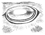
In the Kirkoswald district, one of the most interesting remnants of antiquity was the Lochspouts Crannog. The little lake in which this crannog was situated was impounded by a natural dam consisting of a trap dyke, over which the waters of the loch flowed at several parts, and whence in all likelihood the loch got its name of Lochspouts. Owing to this lake-basin having been drained and cleaned of mud and vegetable debris, for the purpose of its being converted into a reservoir to supply Maybole town with gravitation water, exceptional facilities were offered for having this crannog explored; but owing to the rapidity with which the excavations were carried on, perhaps the most was not made of it. Before anything was done, the crannog site was represented by a grassy mound on the margin of the loch. Five feet below the centre of the mound there was discovered a wooden pavement formed of oak beams, covering the central portion of the area within the circle of piles, the rest being laid with branches and stems of trees, and near the surrounding piles there was a reticulated structure of stakes and beams, which appeared to have been carried all round, and sloped slightly towards the piles, and under the log pavement there were abundance of beams and brushwood. The diameter of the circular part within the piles was 95 feet. Above the log pavement, and separated from it by masses of stones embedded in yellow clay, there were three circular hearths, about 5 feet in diameter. Connecting a rocky prominence which had formed a portion of a former margin of the lake, there was discovered a wooden gangway, which appeared to have been originally always submerged so as to allow of secret access to the crannog. The piles of this structure projected about 2 feet above the gangway, and the horizontal beams were placed in a fan-like manner, leaving lozenge-shaped spaces between. Dr. Munro, who explored this crannog, came to the conclusion that its surface has subsided from what it originally was to a depth of over 10 feet. The relics obtained from it were chiefly got over the area of the log pavement and around the fireplaces, but none nearer the surface of the mound than about 18 inches. Under this log pavement were sometimes got large quantities of limpets and periwinkles. Hammer-stones were pretty common, and some forty specimens were obtained. They were of three types - circular and flat ones, with signs of wear all round the edge; similarly shaped ones, but with the markings on the flat surfaces; and elongated ones, which had been used at one or both ends. Of polishers, two types were got – pestle-like implements and flat ones - one specimen being triangularly-shaped, somewhat like a modern smoothing-iron, and all of them smooth and glossy over their surfaces. Of whetstones, one figured resembles the modern scythe-stone in shape, and another flat one has got a hole in it towards the end for suspension. Three pieces of sandstone were got, with a hole in each, the holes being funnel-shaped off both sides, and somewhat similar to the ' sinkers' got by Mr. James Bennie in connection with the Clyde canoes. Pebbles were abundant in the mound, some having been used as anvils, heating-stones, sling-stones, etc. Eleven quern-stones were. got, nearly all made of granite; but there were only two which could be said with certainty to be under ones. One of them had evidently been used for a long period of time. It was oval, and measured 15 inches by 13, and 5 inches in depth, the mouth of the funnel into which the corn was poured being 5 inches in diameter, the smaller end containing the hole for the handle.
Only one spindle-whorl, and that one made of sandstone, and measuring 1¾ inches in diameter, was obtained. Two polished discs, one not a complete circle, and the other one represented by fragments, were obtained. The largest bit measures 4 inches in diameter. One is composed of a whitish micaceous stone, and is quite smooth on both sides; the other is made of a dark compact stone, highly polished on both sides. These discs may, having been wetted, have been used as looking glasses by the crannog people.
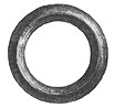
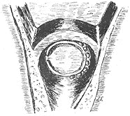
There is an oval implement figured, made of hard gray trap, and measuring 3¼ inches by 25/8 inches in width, its thickness being 15/8 inches. It exhibits thumb-and-finger cavities on each side, and if intended for a hammer-stone, had never been used. This is an exceedingly rare type of stone article in Ayrshire (Fig. 262). Of flints, only two scrapers were got, one nearly circular, and about 2 inches in diameter. Several bits of gas-coal were obtained, some of them showing marks of workmanship - a beautifully made ring, 1¼ inches in external diameter (Fig. 263), and a pendant ring-cross, ornamented by incised rings and short lines, which have been filled with a yellowish enamel, and is perhaps a unique ornament of this type for Ayrshire. Two portions of gas-coal rings like armlets were found.
Of bone objects, there were a pin (Fig. 264), a chisel (Fig. 265), an awl-like instrument, three pointed implements, a spatula, and a knife-handle. .
Of objects in horn, there is a pick made of red deer's horn similar to the ones I got at Ashgrove Crannog, a hammer or club like article, a spear-head, a pointed object, and a knife or dagger handle. A bit had been cut from a roe-deer's horn showing three points, and had been probably used as an implement. Of wooden articles, there was a semi-globular piece, 7 inches in diameter, with a shallow cavity cut out of its flat side ; a cup-shaped vessel, surrounded by a deep groove, which divided its lip into two rims, which were penetrated by nine or ten small pins in holes going through both. These were of soft wood, but an oaken article, 3 feet 6 inches long and 1 foot broad, by 4 inches thick, was obtained, and had been fashioned into an implement of peculiar construction, having a hole in the centre, over which there was a handle, perforated both vertically and horizontally, a projecting piece being at one of its ends, and a groove in its side. It showed marks of having been long in use, and was made out of a solid piece of wood. All the wooden articles were found below the upper log pavement. Of articles in iron, few were got, and these very much corroded, one object having been a dagger, evidently riveted at one time to a handle.
Of bronze objects, there was a small ornament with raised central parts, widening out at the ends, and having on each side a concavo-convex circular boss, and above a loop possibly for suspension (Fig. 266); a key, somewhat modern in shape; and an ornament, which in the drawing presents the appearance of a boiler safety-ball, but which is hollowed in the part representing the ball, its total length over the top of the suspending loop being a little more than 1¼ inches. There was a leaden spindle-whorl-like object got, measuring three-quarters of an inch in diameter.
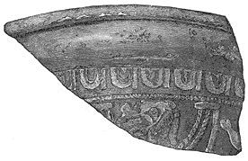
Of vitreous paste objects, there was an amber-coloured bead of the ‘melon’ type, variegated with yellowish slag, smooth over the surface, and about three-quarters of an inch in diameter; a yellowish circular bead, with flat sides; and one, a melon, of similar corn. position, but represented only by a half, and grooved over its surface, the hole in it being constricted by a circumscribing sharp ridge, its diameter being an inch. Another bead, somewhat similar in shape to the last, is made of green-glazed ware, and measures five-eighths of an inch in diameter. Of pottery, there were three kinds - a dark, fine-grained variety, a light-coloured variety, with abundance of sand-grains in its composition, and shreds of Samian ware, represented by four fragments. The bit figured has belonged to a highly-ornamented vessel, 6 or 7 inches in diameter. Conspicuous amongst the ornamentation is the festoon and tassel, or egg-and-tongue border, a very characteristic moulding on this quality of ancient ware (Fig. 267).
The only article remaining to be noticed is a sub-triangular shaped ornament of rock-crystal, nearly an inch wide, and which must have been ground down to its present shape. No doubt such an article, considering its hardness and quality, would be held in great esteem by its prehistoric possessors, the crannogites. The only other rock-crystal article that I know of having been found in Ayrshire was the specimen got at Kilmarnock. The Lochspouts Crannog is described by Dr, Munro in the third and fourth volume of the Ayr and Wigton Collections. As the original bottom of the lake was never reached in the explorations, there can be no doubt but there are a large number of relics lying there yet. At Balchriston there is a fort, situated on a point of land where a small stream branches off from the principal burn. It measures 40 paces in circumference round the top of the wall, outside of which it slopes steeply in front, and to the burns on each side. There has been a ring of large boulders as a foundation to the wall, and the diameter of this ring is 19 paces. On the north side there is the appearance of a gateway. On the land side, towards the east, it has been defended by a wide ditch, the bottom of which is still 13 feet below the top of the rampart. On the south side of the rampart there is a large granite boulder. This fort is situated about 300 feet above sea-level, and from it there is an outlook on the Firth of Clyde; but being placed somewhat in a hollow, the land view from it is limited (Fig. 268). I am indebted for a knowledge of it to the blacksmith of the district, to whom it had been a lifelong enigma.
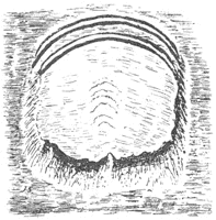
Kirkhill Fort, or Camp, is situated on the top of a hill of that name, which rises 850 feet above sea-level, and from which there is a magnificent view of Mochram Hill, the Dailly and Girvan Hills, and part of the Firth of Clyde. Kirkhill is in all likelihood a corruption of Caer Hill, or the ‘fortified hill’ (Fig. 269). The rampart is on the outside of the ditch, not quite circular, and measures 221 paces in circumference. The centre of the fort rises considerably above the top of the rampart, and right in the centre, on the top of the hill, there is a level platform, 20 paces in diameter, which was probably fortified by a stockaded citadel, and similar to several platforms already described in other districts. This fort has the appearance of having been pitted in several parts, as if someone had been hunting for treasure. The Hollowshean Camp is conspicuous as having been defended by no less than four ramparts on its
east side. Within the inner rampart it measures 93 paces east and west, by 62 paces in the opposite direction. On the south side the ground is naturally steep, and on the north the slope has been scarped for a distance of 12 feet down. The spaces between the ramparts gradually decrease in width in going out from the camp towards the east, the respective distances apart being 14, 9, and 6 paces, measured from the centres of the walls. The two inner ramparts are still complete, there being gateways through each near the centre; the inner one is semicircular, and 80 paces in length, the rest being sub-parallel to it. The northern half of the two outer ones have been removed. There are no ditches in connection with this camp (Fig. 270). The outlook from Hollowshean Camp is also very fine, and when I visited it in April, 1893, its surface was covered with anemones, which looked even finer than those which grow in woods. At a short distance to the west of Hollowshean Camp, on the top of Prop Hill, there is a small mound, 8 paces in diameter and 3 feet high. About the centre of the district there was a Druidical circle, which has probably been removed, and several stone cists were got containing ornaments, as per Statistical Account. Two large mounds of ashes, 10 yards apart, and 30 yards from the sea, were at one time conspicuous, but were removed for manure. They are said by the writer of the New Statistical Account to have contained 4,000 cartloads, and were in all likelihood shell mounds. Between Turnberry and Girvan there are eight large drums of boulder clay facing the sea, parts of some of them having been cut away by the waves during the raised-beach period. On the third one, counting from Turnberry, is the old fort of Dinnymuck* (the fort of the sow), now called Dowhill (probably, and as pronounced in the district, Dubh Hill, or ‘black hill,’ from its having been covered with sloe bushes, part of which still remain). The outer rampart is horseshoe shaped, the part of the fort towards the sea having slipped away, and is 160 paces in length. The inner rampart is 67 paces in circumference, the space within it being hollow, and at parts nearly six feet below the top of the rampart. On the outside of the outer rampart, at both extremities, there are short ditches. There is a narrow platform surrounding the inner rampart, 4 feet below it on the north side, and 3 feet 6 inches on the south side. The ditch surrounding this platform is 12 feet 8 inches below it on the north side, and 10 feet 4 inches on the south side, and runs from 7 to 11 paces wide at the bottom. The outer rampart runs from 3 to 8 feet high above this ditch, and the short ditch on the south side is 10 feet 8 inches below its top. Turnberry Castle, Ailsa, the Girvan Hills, the Fairy Knowe, and Craighead Fort are visible from it. The Coves of CuIzean are six in number, hollowed out of porphyritic rock by the waves when the land stood lower relative to the sea than it does now. The largest one is some 200 feet long, by about 50 feet high at parts. So far as I know, no archaeological exploration of them has ever been undertaken; but I think such an examination would repay the trouble, as they are most likely to have been inhabited at one or several times. On Balkenna, at about the level of the new shore road, stood a large cairn of stones. David Jameson, my informant, who assisted at its removal, said that under it there were several stone coffins, or cists, with human remains.
At Port Morrough, a traditional bay, but now 100 yards inland, and 25 feet above sea-level, situated opposite The Maidens, a group of fantastic rocks between CuIzean and Turnberry Castles, there was found under a ledge of rock, after some soil had been removed, a hoard of five bronze celts, and a bronze ring. Dr. Munro, who describes the find in the fourth volume of the Ayr and Wigton Collections, thinks that there was evidence in the manner of their occurrence to show that the sea had receded considerably since the hoard of bronze celts had been stowed away. The whole five celts belong to the same type, and that the simplest of the bronze celts, formed evidently in imitation of the more ancient stone celt, the chief differences being their comparative thinness - a natural difference, seeing that they were made of a much tougher substance - and a widening at the cutting edge. This ‘kit o’ tools’ is nicely graduated in size, the intermediate ones having undergone the most wear by work; and the find is probably unique, and points to a time when the art of the carpenter, aided by the use of metal implements, was first known in the land. The largest of these bronze celts measures 5½ inches by 41/8 inches wide, by 2/3 of an inch in thickness; and the smallest, 3¾ inches by 1½ inches, by 1/5 of an inch in thickness (Fig. 271). The bronze ring is a penannular one, 27/8 inches in external diameter, circular in section, with a thickness of ¼ of an inch. This find was certainly a very interesting one,and if similar finds were as promptly brought before the notice of the proper authorities, archaeological science would make rapid progress, and our knowledge of antiquities increase by leaps and bounds. *It may mean the strong-house of the Monk; muk being the Norse word for Monk. A rapier bronze sword was discovered in a moss, but where is not stated. If it is the same article as is described in the New Statistical Account as a ‘very curious spear,’ it must have been found some sixty years ago. It is figured in the fourth volume of. the Ayr and Wigton Collections, and measures 15 inches in length, and 2¼ inches across the handle plate. A dagger-blade, or halbert, of bronze is figured beside the above, and measures 14¾ inches long, by 4 inches broad at the widest part, and has three rivet holes at the base, with a rivet still in one of them. It was found near Crossraguel Abbey, and is in the National Museum at Edinburgh. Between Kirkoswald village and the sea, half a mile distant from the latter, is a mound called Shanter Knowe. It is situated on the summit of a rising terrace which overlooks the beautiful bay of the Maidens. This mound is nearly circular, 90 paces in circumference at the base, 33 feet in diameter at the flat summit; and its height is 12 and 20 feet, being placed on sloping ground. It has been partly explored by Lord Ailsa, who describes and figures it in the seventh volume of the Ayr and Galloway Collections. No articles were got in this mound nearer the surface than 5 or 6 feet, or deeper than 12 or 13 feet. The following were the finds : Periwinkles; limpets; bones or horns of ox, horse, sheep or goat, swine, red-deer, roe-deer, and dog; well-made flint scraper; fragments of flint; quartzite hammer-stone; bronze pin, 2¾ inches in length; whorl of lead 1 inch in diameter, with central perforation; portion of an iron curb-chain; iron slag and fragments of glazed and unglazed wheel-made pottery. From the, number of edible shells that were got, this had probably at one time been a shell mound, subsequently heightened and converted into a moote hill or fort. At the south end of Maidenhead Bay is Rab’s Knowe, a subconical, grass-grown, mound-like old sea stack rock, quite suitable for a fort. Near it, and just to the south of the Weary Neuk, is Th’Stinnen Stane, a dolerite block, or monolith, erected on the summit of a bit of rising uncultivated ground. It is 5 feet high, by 3 feet 6 inches by 2 feet, its surroundings being exceedingly picturesque, part of them including the ancient policies of Turnberry Castle, now an extensive grassy plain, partly broken up by bent-covered sand-hills. The Dounan Knowe on Drumbeg, and close to the shore-road, has probably been fortified. At one time, when it was being divested of brushwood and brought under cultivation, a number of human bones were brought to light, as I was informed by an old man over eighty years of age, called David Jameson, who remembered seeing the skeletons. The Fairy Knowe, an artificial mound, is on Balkenna, close by the shore road, and is situated on a drum of boulder clay. It measures 37 paces by 11, and is 9 feet high. According to a tradition of the neighbourhood, it was erected by the Danes in a single night. The castles of the district are Turnberry,* thought to have been the Perigonium of the Romans, destroyed by Bruce in 1308; Thomaston, built by Bruce's nephew in 1335; CuIzean, built in 1777 near the site of a more ancient one called Cove Castle. Crossraguel Abbey was founded by the Earl-King Duncan in 1260, demolished by Percy in 1307, built again and inhabited by the monks for thirty-four years after the Reformation. The Abbey, Chapter-house, Abbot’s house, Port, and Dovecot are still pretty entire. There is the round tower of an old windmill a short distance to the south of Maidenhead Bay. |
|
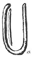
In the Dailly district (the vale or valley) there are, about a quarter of a mile east of Blair Farm-steading, a series of three wall-like mounds. They are each 13 paces in length, lie parallel to one another, and are included in a space of 8 paces wide, their average height being about 2 feet, the middle one having a short spur at the end. Fourteen paces east of the above, there is a U-shaped wall-like mound, similar in size to the three described - viz., 13 paces by 8 - the open end of the U being towards the east. * Bruce’s Castle
It is not easy to conjecture what these structures may have been used for, and nothing is known about them in the district.. Can they have been ‘Picts’ kilns’ for making charcoal, wherewith the ancients smelted and fashioned their iron and bronze weapons, implements and ornaments (Fig. 272) ? On Dobbingstone there is a moat-like hillock, which is entirely natural, having been carved out of the boulder clay by the joint action of two streams, and in the glen of the larger stream there is the most magnificent display of that formation in Ayrshire. Above this moat-like hillock there is a rampart-like structure running for some distance, which took me some time to convince myself was also a natural production. The burn at the base of the mound-like hillock has so fortified it by a trench that it, the mound, may have been used as a fort, and at one part there seems to be a bit of artificial ditch. The surface of the hillock is 29 paces long by 9 paces wide, the sides being very steep. On Hadyard Hill, on the lands of Maxelton, there is a camp, locally known as ‘Bruce’s Camp.’ It is situated towards the south-west end of the hill, and commands an extensive view, the lower part of the Girvan Valley, with its finely-wooded clumps and mansions, being just beneath the hill to the west, a large part of the Firth, the Girvan Hills, Knockdolian’s top looking over them, and the numerous hills stretching away towards the east, are in view from this coign of vantage.
This camp still shows considerable portions of two ramparts and two ditches, the ramparts being placed on the inside of the ditches. Commencing at the south side, the outside ditch and rampart, measuring along the bottom of the ditch, extends for a distance of 224 paces; then there is a break, where the ditch is filled up, of 15 paces. The gateway may have been placed here, as there is an opposing break in the inner ditch. Continuing along the outer ditch, it sweeps round for 66 paces further, when the hillside becomes so. steep that for 110 paces there was no need of either ditch or rampart on the south-west side. On the south side, the inner ditch and rampart extend further round towards the west by 31 paces than did the outer ditch and rampart. There is a gap of 11 paces, and then the inner ditch begins again, being 8 paces inside the outer one, and sweeps round for 158 paces, which brings it to the gap spoken of (the gateway?), which is 10 paces wide. Here the inner ditch is 25 paces within the outer one. It extends for a further distance of 57 paces, when it conies to the steep part of the hill already spoken of (Fig. 273). Twenty-three paces to the east of the camp there is a split boulder of fine-grained gray granite. Craighead Hill is one that should not fail to be visited by the geologist, as besides the fine view to be obtained from it, its summit has been carved out into numerous natural hollows. To the south-west of it there is a prominent, crag-and-tail little rock, and situated on the crag-end of it there is an old fort, which I have called Craighead Fort. Its summit is 24 paces by 15, and is for the most part surrounded by granite boulders. Mochrum, Kirkhill Camp, Turnberry, Ailsa, and Dinnymuck Fort are visible from it, the view towards the east being limited by Craighead Hill. I asked the Rev. George Turnbull to give me some particulars about the Charter Stones of Dailly, which are unique in Ayrshire, and he has very kindly sent me the following notes: ‘There are two stones, which tradition calls the Charter Stones of Old Dailly. They lie in an enclosure attached to the ruined church of Old Dailly, which is pre-Reformation, and very old. The enclosure (in which they lie) is sometimes called a "vestry," but it is rather supposed to have been the burying-place of the Boyds of Trochrague. The stones were used in bygone times as in trial of strength, the smoothness, as well as the weight, making it difficult to lift them. They were once taken away, and thrown into the river (Girvan); but the people of Old Dailly fished them out, and restored them to their place. They are bluish, and very hard.’ The facts of these stones being called charter stones, and also used as tests of strength, is very interesting, and would seem to indicate that nobody in the district was at one time allowed to hold a charter unless he was of sufficient strength to lift one of them, or perhaps both. The practice might be revived over the length and breadth of the land without in any way proving detrimental to the national physique. In the district two large bronze rings were at one time dug up. In St. Andrew’s College Museum there is a bronze sword-sheath of elegant workmanship, found in a drain near Bargany House. It is figured and described by Dr. Munro in the seventh volume of the Ayr and Galloway Collections. In length it is 24 inches. At Kilkerran a bronze chaldron, along with bronze socketed celts and fragments of bronze swords, were discovered ; and towards the east of the district, at the base of the hills, a granite quern was found. The castles of the district are Penkill, inhabited and situated in a romantic glen, there being an older castle of that name which exists as a ruin; Dalquharran Castles, an inhabited one and a ruin; Kilkerran Castle, and the site of Drumellan Castle. At the foot of the romantic little Lady Glen there was situated Lady Chapel, and Mackrikil (Machar-a-Kill) was the site of another chapel, and near it there was got a socket of a cross, which measures 4 feet 2 inches high, and .3 feet 6 inches by 3 feet at the base ; smaller at the summit, as it is calvered, and steps in twice. The socket-hole is 2 feet by 8 inches, and about 1 foot in depth. Another relic has been made out of a rough boulder of sandstone, and measures 2 feet 9 inches by 2 feet 7 inches, and 1 foot 7 inches. On it there is a small incised cross. It is conjectured to have been a ‘Knockin’ Stone,’ and if so is unique in having a cross inscribed on it, as Dr. Anderson remarks, and adds that the cross may have been intended to bless the barley that was being prepared in it. Both of these stones have been figured and described at some length in the third volume of the Ayr and Wigton Collections by Mr. William Galloway. On the same site there was a small monolith, which has been removed from its original position. In the churchyard there are some grave-slabs, which are inscribed with the sword and cross, and shears and cross. A circular pyx of brass was at one time dug up near Dalquharran Castle. It was filled with coins of Edward I and Edward II of England, and two counterfeit sterlings of the Count of Flanders and Porcieu, and is figured in the seventh volume of the Ayr and Galloway Collections. Ailsa Craig formed part of the Barony of Knockqerran in Dailly parish, and on it there is a ruin. There is a Covenanters’ monument in the Old Dailly churchyard to Semple and MacLorgan. Dailly was anciently Dalmaolkeran, or land of the bald-headed (saint) Keiran. Elliot Stock, 62 Paternoster Row, London |