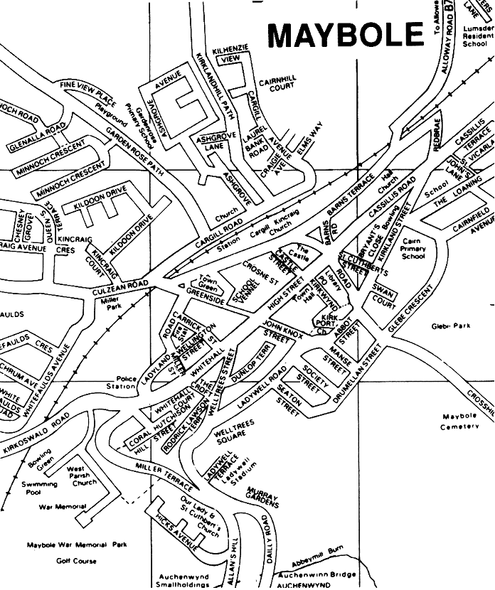
Chapter 11 STREET NAMES HISTORY is often bound up in street names and although many streets in our old town have been renamed over the years a study of them can be most interesting and show how different communities, trades, etc., grew, flourished for a while, and dwindled away only to leave in the name a record of their existence. Unfortunately about the end of the nineteenth century (and even in recent years) there were many alterations to street names and descriptive old names such as Smithy Brae, Weaver Vennal, New Yards, etc., have been changed to what are considered more "genteel" names. The old names will always be remembered by the older residents, however, and even by the younger generation who hear their elders speak of Ladywell Road for instance as Weaver Vennal, and it is to be hoped that the old names will not be entirely forgotten by coming generations. To many it will be surprising there are over seventy streets in Maybole and every street name has a meaning attached either to local events or people or to national events such as the coronation of Queen Elizabeth which is commemorated in Queens Terrace. Abbot Street. At one time the Abbots of Crossraguel had a town house in this area. Near it stood the Black House which was one of the oldest houses in Maybole before it was demolished in 1967. It belonged to the Dominican Friars who dressed in black robes, and, being itinerant preachers, had resting places throughout the country. At one time the Black House was occupied by a Prebend of the Collegiate Church, which was built just behind the house. Near to it, where the new houses on Crosshill Road are built, was the garden for the Abbots House, and the area is still known to the older folk as "The Garden of Eden". Academy Quadrant. So named because it is adjacent to the Carrick Academy. It is part of the Council Housing Scheme between Kirkoswald Road and Culzean Road. Allans Hill. This was one of the oldest exits from the town to Dailly and Girvan and is believed to be a corruption of the Gaelic "Alt-nan-hill" or "hill beside the burn", in this instance the Cairders Burn where the weavers of Maybole used to "caird" or wash and comb the wool for weaving. Another derivation of the name is from the Anglo-Saxon "aelron" (or alder tree) but the Gaelic derivation is the most fitting. Alloway Road. Descriptive in itself and is the road to Alloway. Ayr Road. Again just the road to Ayr and is only the short part of the highway from the foot of the Lovers Loaning to Lyonston Farm. Ballony. A very old name in the town and formerly a small farm. Believed to mean the house or dwelling place of John. It was formerly outside the town boundary but about the end of the nineteenth century the farm lands were purchased for the town's sewage works and refuse coup and were used as such for many years until the new sewage works were formed near Littleton Farm in the 1960s and the public coup was moved to an old quarry at Kirklandhill Farm in 1969. On the farm lands was formed the town's first football pitch where before the first World War the Maybole Football Team played Glasgow Rangers in the first round of the Scottish Football Cup. The game is remembered by the older town people but the score conveniently forgotten. The present football pitch at Ladywell Stadium is on the same site as the original ground. Barns Road and Barns Terrace. The public barns for the town stood on this area and the townspeople had the right to store their grain etc. in these barns. Where Barns House now stands was the town "pound" where stray horses were impounded until their owners could bail them out. This was the forerunner of the present method of dealing with cars wrongly parked, or left unattended for too long, and towed away to a "pound" by the police. Cairnfield Avenue. Named because it is near the Cairn School which was built on a field which at one time had a cairn in it to mark some forgotten incident in local history. Before the local council built Cairnfield Avenue it was a large field owned by the Carrick Farmers Association and for very many years was the site for the local Agricultural Show which was one of the highlights of the year's activities for the local people. Cargill Avenue and Cargill Road. Commemorates the time when Donald Cargil the great Covenanter preached at the conventicle held in May, 1681, on the lands of Cargilstone Farm, just outside the town. A large stone marked the site of the conventicle and part of this stone is built into the wall of the Cargill-Kincraig Church in Barns Road. The conventicle was held in the field on the Cross Roads behind the Covenanters Memorial which was erected to commemorate the death of the Maybole Covenanters who were taken prisoners at the Battle of Bothwell Brig. Carrick Street. Refers to the region of Carrick of which Maybole is the ancient capital. Carrick means "hilly or craggy place" and is mentioned in Roman history about 80 A.D. Cassillis Road and Cassillis Terrace. Formerly called New Yards as the ground was occupied in olden times by the stack yards of the Earl of Cassillis. It was a custom to pay farm rents at one time partly in kind and the grain and straw paid in kind was carted to the lands adjoining Maybole Castle, which was then the town residence of the Earl of Cassillis, and stored in the "yards". This was used for feeding cattle given by other farmers as rent for their farms and the cattle were held and fed in the yards until they could be sold at market. The Rev. Roderick Lawson (who was responsible for changing many of the couthy and descriptive street names) persuaded the civic fathers to change the name from "New Yards" to Cassillis Road, thus still connecting the road with the Earl of Cassillis, but to most townspeople it is still the "New Yards". Castle Street. Named because of its proximity to the Castle. It was first known as the "Fore Vennal" but later became the "Foul Vennal" because a drain ran down the centre of the street and in wet weather it was rather unpleasant and the Councillors arranged for it to be causewayed in 1775 to remedy its foul condition. The name was changed for a short time to "Post Vennal" because the Mail or Post vans were stabled there, but about the end of the nineteenth century it was finally changed to Castle Street. It is a pity the common-place "Street" was used and not the ancient Scottish "Vennal" so often come across in Edinburgh, and surely every bit as suitable for the ancient Capital of Carrick. Chesney Grove. Named after a well-known benefactor to the town, Mr. Harold Chesney. Although an Englishman he came to Maybole, married the daughter of a well-known Provost, James Miller, and became a staunch "Minnieboler" by choice if not by birth. He was ever ready to help in all matters relating to the town's welfare and the Councillors, when the new street was formed, perpetuated his name in "Chesney Grove" in recognition of his many services to the town. Coral Glen and Coral Hill. It is strange to find such a name in an old Scottish town but it has no connection with blue seas and coral strands. Originally the old quarries from which the stone was quarried to build the old houses in the town stood in this glen and through time the "Quarry Glen" was corrupted to "Quarrle Glen" and finally to "Coral Glen". There are also deposits of "quarl" or fireclay in the glen and probably this also was corrupted in time to "Coral". In "The Glen" is the well-known "Cockydrighty" or "Wee Spout in the Glen" with the inscription above it, "Ye may gang further and fare waur" A small lane running parallel to the Coral Glen was known locally as the "Sma' Glen". It was in the "Sma' Glen" that the "Lodging Houses" housed most of the "randy beggars" which the douce townsfolk complained about to the Council in 1792 and the last of these "Lodging Houses" still stood, and was in use, until after the first World War. Crosshill Road. Merely the road to Crosshill. In former days the "Garden of Eden" was here and last century a lemonade works and the slaughter house stood in this street. The ground behind these buildings was for many years used as a fairground and, until the Council built a housing scheme on the site, the once pleasant "Garden of Eden" was a derelict wasteland. It must have at some time been used for burial purposes as when the area was cleared for building some very old tombstones were found buried in the ground. The Croft. The steep lane leading from Whitehall to Welltrees Street is commonly called "The Croft" but the full and correct name is "Croft-e-geish" meaning the "Lane of the Geese". Centuries ago many townspeople kept flocks of geese which were driven daily to graze on the marshlands round the "Bog" and each night again driven up "The Croft" to pens sited near Ladyland Road. Culzean Road. Until the end of the nineteenth century this was known as "The Shore Road" being the way the towns-people flocked on summer days to Croy Shore. Now the name signifies it is the way to Culzean Castle, for so many years the home of the Kennedies, the Kings of Carrick, and now one of the best known properties belonging to the National Trust for Scotland. It was in this area on a field known as the "Muster Lea" that the Maybole Covenanters gathered, or "mustered', to march off to defend their cause at Bothwell Brig in 1679. The town gallows, where public hangings used to take place, were sited at the top end of Culzean Road on a spot now occupied by a house known as "The Knowe". Prior to being named "Shore Road" the name given to it was "Gallow Hill" a name still used by many of the older residents. It was near Whitefaulds Farm on Culzean Road that McAdam first experimented with his new style of roadmaking which gave the world "macadamised" roadways and made transport so much easier. Dailly Road. Again now merely descriptive as the road to Dailly but formerly known as Masons Row. The old name was a corruption of "Maison Dieu" (House of God) and a Hospice or "spittal" connected with the Old College stood here at one time. Where the "Sma' Glen" joined Mason's Row the site used to be known as "Bryce's Corner". A well-known local character, Rab Bryce lived here, who enjoyed nothing better than a "guid gaing fecht". In one such differences of opinion after a ploughing match when he was wielding a stick to good effect he was asked whose side he was on and answered, "on nae side ava; I'm just for ma am han'." Drummellan Street. About the end of the nineteenth century this was one of the old streets renamed at the instigation of the Rev. Roderick Lawson, and was so called because the lands around it belonged to Mr. Kennedy of Drummellan House (formerly known as "Machrie Mhor" as far back as 1721). The old name of the Street was "Dangartland", a name still commonly in use, because at one time it formed part of the estates of Dangart in Colmonell Parish. Mr. Kennedy of Drummellan proposed to form a new street to the south east of, and parallel with, Drummellan Street and plans were drawn up for it but the street was never formed. The name of the new street was to be Primrose Lane in honour of Mr. Primrose Kennedy of Drummellan who was a Provost of Ayr and whose memorial in the form of a granite obelisk stands at the south end of Sandgate in Ayr. Local people nicknamed the proposed new street "Blue Pansy Street" and among the older folks this name is sometimes used for Drummellan Street. Dunlop Terrace. This is one of the streets formed in the new housing scheme built on the steep slope between Whitehall and Ladywell Road and was named after Provost John Dunlop who was for many years Housing Convener in the Town Council. Enoch Road. A Street in Gardenrose housing scheme, formed in 1970 and named because it overlooks East Enoch Farm. Gardenrose Path. This road led to Gardenrose Farm and at one time was one of the exits from the town. The street really takes its name from a house (commonly called the Bumbee because the householder kept bees which used to stand where the railway bridge is in Culzean Road and not from the farm of Gardenrose which was built much later. Locals know the road better as "The Near Path" to distinguish it from "The Far Path" or Kirklandhill Path. Glebe Terrace and Glebe Crescent. These roads were formed on the lands of the glebe belonging to the manse of the Old Parish Church and are self explanatory. Glenalla Road. A street in the Gardenrose housing scheme so named because it faces Glenalla Fell, a well-known hill above Crosshill. Greenside. This roadway circles the open space known as the Town Green and is most suitably named. Formerly, it was here the townspeople practiced archery, played bias bowls, "gowf" and held fairs. At one time the authorities forbade the playing of "bias bowls" as the townspeople were neglecting their archery practice. Sir Walter Scott in one of his novels mentions Maybole as being one of the last towns in Scotland where the archers' sport of shooting at the popinjay was practiced. In the 18th and early 19th centuries the grazing on the Baligreen was rouped annually by the Magistrates of the town and the usual rent was about 5/-. High Street. Now the main street of the town although formerly only a roadway between the Tolbooth at the top and the Castle at the bottom of the roadway. These buildings sat across the street at one time and the only approaches to it were up the Kirkwynd and what is now John Knox Street. The street was much broader in former days but the newer buildings on the south side were built in front of the older buildings, many of which still stand behind the present shops and this narrowed the roadway considerably. The Town Cross originally stood halfway up the street but was removed in October, 1773, because it was obstructing traffic and the site is now marked by an iron cross set in the middle of the roadway. It was in this street that Robert Burns' father first met his future wife, Agnes Brown, at a booth erected for one of the Town Fairs and the spot where they first met is marked by a bust of the poet set on top of a gable over a shop near the bottom of the street. Although Rev. Roderick Lawson states this street was at one time called Main Street, there is no reference in any Town records at any time to such a name, although it is marked "Main Street" on an old ordnance survey map of last century. Abercrombie refers to it as High Street and the council minutes of 4th June 1745, ordained that the "High Street" should be causewayed. The name originally merely meant is was the High Street up the hill above Abbot Street which was then the main street of the town. On 5th November, 1744, it was ordained that all public proclamations would be made from the Cross in High Street and such proclamations should be preceded by "tuck of drum". Hicks Avenue. Named by the Town Council to commemorate the services given to the burgh by Provost Thomas Hicks, who for many years was a member of the Council and took a great interest in the town's welfare. Hutchison Street. The houses here were built by a man called Hutchison and the street was named after him. Locally the street is commonly called "The Hill" which is a most suitable name as it stands high with a wonderful view over the Southern uplands. Inches Close. Derived from the Gaelic "innis" meaning a narrow place and a most suitable name as formerly it was just a narrow close or lane. For some years it was named Buchanan Street, but fortunately the old name has been resumed and it is hoped will remain. It has been said the street was called after an old worthy nicknamed "Inch-aboot" but this is most unlikely. John Knox Street. The old name, still in common use, was Red Lion Brae so called from a public house "The Red Lion" which was in the street. It was earlier known as the Back Vennal leading up to High Street. It was in a house in this Street in 1562 that the famous debate between Quintin, Abbot of Crossraguel, and John Knox took place and again the Rev. Roderick Lawson persuaded the civic fathers to change the name to commemorate this event. Fortunately this change was quite logical and not too harmful to the history of the street names, as many others were which were changed for no good reason. The house in which the debate took place became an inn known as the "Red Lion" and after it was closed another inn at the foot of the hill took the same name. Kildoon Drive. A new street formed in 1969 by the Town Council in the private housing development at Gardenrose Farm, and so named because it looks to Kildoon Hill. The old spelling was "Culdoon" and not "Kildoon" and the name means "the brown hill". Kincraig Avenue, Kincraig Court and Kincraig Crescent. From the Gaelic "Cean-no-creige" meaning the end of the rock or hill. In this instance the names refer to the site being at the end of the hill above the town where a small croft known as Kincraig once stood. Kirkland Street. The name is self explanatory as the lands here belonged to the old Church built at the foot of the Kirkwynd and it is an excellent example of how names arose from simple and logical beginnings. Kirkwynd and Kirk port. The road down to the old church of St. Cuthbert. "Wynd" is the old Scots word for road or street and "port" means gate. This was a most important street at one time and many baronial mansions for the surrounding nobility were built here. It was in the Kirkwynd, about halfway down the hill, that the "Little Chamber" stood, where disputes among the inhabitants were settled at a form of court and where "swords and daggers" were to be left in the "outer chamber" before the disputants entered the "Little Chamber". In the 19th century the Kirkwynd was renamed "Grey Street" by the Town Council but fortunately it soon reverted to its fine old original name. Kirklandhill Path. The road to Kirklandhill Farm and known locally as the "Far Path". Before the railway was formed this road was a continuation of the Castle Brae and at that time ran down the side of the Cargil-Kincraig Church. Kirkmichael Road. Formerly known as the "Cottage Road" because it led to the Cottage of St. Johns just outside the town but now it merely indicates it is the road to Kirkmichael Village. Kirkoswald Road. Again indicative of it leading to the village of Kirkoswald. At the junction of this road with Coral Glen stood a wall locally known as Parliament Dyke where the local worthies met to settle the affairs of state. Before then a smithy stood on this spot, known as Crossmillhead, and this old name is often referred to in old titles of properties in this area. The smith at Crossmillhead was a well-known worthy and the smithy was a gathering place for many of the local people who sat and argued on the wall outside the smithy on good days and round the forge on bad ones. When the smithy became derelict and was taken down the dyke remained and became the gathering place of the locals, giving rise to the name Parliament Dyke. Ladyland Road. This street was formed on lands belonging to the Church of St. Mary and means the lands of Our Lady, again a simple and descriptive name. Ladywell Road. Until the early 1950s this street was known as Weaver Vennal (or simply "The Vennal") and was one of the most suitably named streets in the town. This was the main street of the Burgh for centuries and in it lived most of the weavers who made Maybole famous in the 18th and 19th centuries as one of the best known weaving towns in Scotland. The old descriptive name was changed in 1952 by the Town Council to Ladywell Road, meaning the road to Our Lady's Well, which is at the foot of the Bog Brae at the former Miller Tanning Company's factory. Ladywell Terrace. Similar to Ladywell Road and adjacent to Our Lady's Well. McDowall Terrace. Formerly a group of old houses known as Duncanland which was the oldest name in the town and commemorated Duncan, Earl of Carrick, who granted the first Charter of the district in the 12th century. About 1966 the old houses were demolished and new houses built by the local council and the name altered to McDowall Terrace in honour of the then Provost of the town. Manse Street. Named after the old manse of the Parish Church at Kirkport which at one time stood on this site. Miller Terrace. Commemorates Provost James Miller a well-known Provost and benefactor to the town in the first half of the 20th century. Miller Street. Simply named after the builder of the houses in the street. Minnoch Crescent. A street in the Gardenrose Housing Scheme which looks towards the well-known hill of Shalloch-on Minnoch. Mochrum Avenue. A street in the new council housing scheme at Whitefaulds built in the 1940s and named because Mochrum Hill overlooks the area. Murray Gardens. When the Council built a new housing scheme on the lands of old Ballony Farm, the street was named after Provost Thomas Murray, who was then Provost of the town. Old College Lane. The lane leading along the side of the old Collegium and is one of the oldest lanes in the town. Park Terrace and Park View. These two rows of red sandstone houses were built about the end of the 19th century with an uninterrupted view over the Lyonston or Sheep Park, which, until the 1950s was a beautiful natural park used by the towns-people for playing football, cricket, etc. and the name is self explanatory. Queens Terrace. Named in commemoration of the coronation of Queen Elizabeth in 1953 as the street was formed at this time. Red Brae. At one time, before the railway was formed, it was a continuation of the High Street to Ayr past Lumsden Home and joined Kirkland Street at Duncanland Toll. The street was partly formed through a cutting in the hillside and, as the earth was reddish coloured, the street was commonly called the Red Brae and finally this became its official name. Roderick Lawson Terrace. When the council built this street in the 1950s they decided to name it after the Rev. Roderick Lawson, who was Minister in the West Church in Coral Glen for many years last century and who took a great interest in the town. St. Cuthberts Road and St. Cuthberts Street. St. Cuthberts Road formed in 1868 was named after the Patron Saint of the town and has been so called since it was formed from a path down the side of a burn which led from My Lord's Well (or the Pump as it is commonly called) to Abbots Place (or Pat's Corner) at the Old Cemetery. The old name of St. Cuthberts Street was Smithy Brae or locally "Smiddy Brae" because a smithy once stood in this street where Gladstone Place now stands. Unfortunately this was another of the old descriptive names wiped away when the mania for renaming streets was so rife at the end of the 19th century. St. Cuthbert was once a shepherd lad near Melrose and became one of the most revered saints in Britain. His bones, or rather his well preserved body, was carried from place to place by the Monks of Lindisfarne, when they were fleeing before the Danes and it is said it rested in Maybole district for a time and therefore St. Cuthbert became the Patron Saint of the town. School Vennal. One of the few descriptive names fortunately remaining in the town. This vennal or street led from the top of High Street to the Ballgreen where the school was sited in the 17th and 18th century, and the name is so clear and meaningful it is hoped it will never be altered by well meaning but often so misguided, street name reformers. Seaton Street. The first house built in it was occupied by a man named Seaton and the name of the householder remained when other properties were built. The old quoiting ground was in this street which led down to "Bryces" grain stores, now converted to a haulage contractor's garage. St. John's Lane. A path connecting Cassillis Terrace and The Loaning named because it is formed on lands formerly belonging to the proprietor of St. John's Cottage. For years it was officially unnamed, but locally nicknamed "Calcutta Lane" because it was unlit and a member of the Council once likened it to the Black Hole of Calcutta. The lands on which St. John's Cottage now stands was formerly known as "Bogend". Society Street. In this street in 1824 the Maybole Benevolent Society built a house for letting to "workpeople and their families belonging to Maybole" and because of this the street was named Society Street. Maybole was one of the first towns in Scotland to form a Benevolent Society which built workmen's houses. Swan Court. The old manse for the Parish Church in Cassillis Road stood here for about one hundred and fifty years. In 1967 it was demolished and a new council housing scheme built on the site. The name commemorates the Rev. David Swan who for many years was minister of the old Church and resided in the Manse. In this instance the Council deserve credit for choosing such a suitable and attractive name. The Loaning. Formerly the Bullock Loaning and at one time the north entrance to the town. It was down this lane or "Loaning" that the townspeople drove their cattle to graze on the common grazing lands around St. John's Cottage in the days when all townspeople had the right to graze on free lands. Vicarland. A simple and concise name plainly descriptive of the fact that the land belonged to the Church at one time. Part of this area was formerly known as "Garleffan" meaning "the place of the Druid's Stones". Wellington Street. Originally named in memory of the great Duke of Wellington. Commonly known to the older towns-people as "The Peameal Row" because it is said the person who built the properties was so miserly he fed his family mainly on peas-meal. Whitehall. At one time the Carmelite Friars owned a house sited approximately where the Royal Bank now stands. As the members of this order wore white robes, the house was known as the Hall of the Whitefriars, and when the street was formed the name Whitehall was given to it. After the Carmelite's house was demolished an Inn was built on the site and named the Sun Inn which became a famous coaching inn. Whitefaulds Avenue, Whitefaulds Crescent and Whitefaulds Quadrant. These streets in the Council Housing Scheme take their names from Whitefaulds Farm, as the scheme was built on part of the farm lands. At one time stock was grazed or "folded" on these lands which were rather poor, with a whitish weak grass and the local name of the "white folds" or "faulds" has happily remained to this day. It is a pity, however, that the name was trebled as this is the area near where McAdam experimented in roadmaking and when the roads were formed it would have been a wonderful opportunity to have commemorated the fact by naming one of them "Macadams Way". Welltrees Street. The spring at the foot of the hill locally known as the "Welltrees Spout" gives its name to this street. Formerly there was a large tree beside the well, but this was thought to be dangerous and was cut down in May, 1939, although when it was felled it was found to be perfectly sound and would have stood for many years. The street is locally known as the "Kildoup" and it has been said there was a malt kiln in the street which gave rise to the local name. This can hardly be correct, however, as a Street running from Whitehall (at the site of the House of the Carmelites) went straight down to the Black House at Abbot Street and this was then known as the "Kildoup" being a corruption of "kildubh" the Gaelic for "Black Church". It was only in the 19th century that the street was formed to turn sharply to the right near the junction with Whitehall, to join up with Weaver Vennal near the foot of the Croft. This new street continued to be called "Kildoup" until it was changed at the end of the 19th century. While every street in every town must be given an official name for rating and postal purposes, it is common practice for local people to give nicknames to streets or to certain areas or houses in them. These local names are often more descriptive and humorous than the official names and Maybole does not lack in such unofficial names. These have been handed down from generation to generation and it is hoped will never be forgotten as much of the history of the old town is wrapped up in them. The following are some of the local names with which the true "Minnieboler" replaces the names shown in the Valuation Roll. New Yards. Now Cassillis Road and the explanation for the old name has already been given. Peameal Row. Wellington Street and again previously explained under this street name. Pat's Corner. At the corner of Kirkland Street and Crosshill Road. A man called Pat O'Hara had a well-known public house here and his name is still given to this area. Bumbee. At the road bridge over the railway on Culzean Road. Formerly Gardenrose Toll stood there and the owner kept an apiary of "bumbees" in the garden. In former times it was the accepted place to settle schoolboys' quarrels and all school-boys were aware of what was meant when he was challenged to "meet at the Bumbee" after school hours. Sebastapool. The open space at the bottom of the Kirkwynd behind what used to be a barber's shop (Scobie De Morrow or De Blitt) in front of the entrance to the old cemetery. It was here that the weavers and shoemakers settled their disputes as did the schoolboys at the "Bumbee". Curiously enough a narrow passage led from here to St. Cuthberts Road and this passage was locally known as "Bumbee Lane". Mushroom Row. The row of small cottages in Kirkland Street in front of the entrance to the Cairn School. These houses were built so quickly it was said they rose like mushrooms. Brandy Row. Now offices of the building firm of M. J. Callaghan Ltd. in Alloway Road but at one time a block of tenement houses. At a card game in a local public house the players became rather tipsy and one, who had been losing a great deal of money, put up the tenement property to cover his stakes. He unfortunately lost on the evening's play and the winner claimed the property which ever afterwards was known as Brandy Row, as a concrete example of the evils of drink and the devil's cards. Townend. A row of cottages near Brandy Row on the High Road to Ayr which were the last houses in the town in this road. Town head. The area at Duncanland Toll. This was the top end of the town at the old Duncanland houses. Johnstone's Close. Formerly Jardines Close and was entered originally from High Street before the shop (The Chit Chat) at the junction of Kirkwynd and High Street was built. In the second part of the 19th century the properties in the yard were purchased by William Johnstone, a master slater, and although the Council officially named it Waverley Place it is commonly known as Johnstone's Close. Smithy Brae. Commonly known as "Smiddy Brae" and is now St. Cuthbert's Street and described under that street name. Black House. Now demolished but it formerly stood in Abbot's Street next to the "Auld College" and was the oldest house in Maybole. It was built originally for a Prebend of the old Collegium. Runcie Row. The nickname given to part of Ladyland Road because the houses in it were built by a man Runcie who owned a shoe factory at one time in the hall at the bottom of the Greenside. Primrose Lane. A local name for a proposed new street at Dangartland, or Drummellan Street as it is now called, and the origin of the nickname is given under the description of that street. The Breek. - A house with this name formerly stood near the Cairn School and the old name was often used by the older townspeople. It is now demolished and forms part of the school playground. The origin of the name is unknown. The Royal Billy. A house in Welltrees Street was once used as the headquarters of the Orange Lodge in Maybole and it was locally known as "The Royal Billy" or more commonly just "The Billy". Tradition has it that when the Orange Flute Band was first formed its members decided to practise in the house, but at the first rehearsal the noise of the big drum brought down the ceiling and afterwards the band practised in the garden behind the house. Gallow Hill. Now Culzean Road but to townspeople still the "Gallows" Hill or "Gala Hill" in memory of the fact the town gallows stood here. Maybole people still gleefully remember that the last man hanged here was a Girvan man for killing his neighbour in 1718. Eye witnesses to the crime could not be produced but the fact he was a Girvan man was sufficient to convict him in the eyes of his Maybole judges. The rivalry between the "Tacketies" and the "Syboes" still exists but in a less lethal form. The Bench. The local nickname given to the house which stood at the bottom of Kirkland Street near Pat's Corner. A small raised front garden at the house was shaped rather like a cobbler's bench and gave rise to the name. The house was demolished in 1969. Parliament Dyke. At the head of Coral Glen where iron railings now separate the Glen from Kirkoswald Road there was formerly a low dyke or wall which was at a height that made a comfortable seat for old worthies and the origin of the nick-name is explained under the item referring to Kirkoswald Road. Cockyrighty. The spring in the Coral Glen which discharges from the hill on which the West Parish Church is built and often simply known as the "Wee spout in the Glen". The Pump. The site of the well which supplied Maybole Castle and which, as it originally stood in the Castle Garden, was known as My Lord's Well. When the Castle kitchens, etc., which originally blocked the bottom end of the High Street were removed and Cassillis Road was formed a pump was erected over this open, or draw well, by public subscription in 1806. In 1869 when the new road (St. Cuthbert's Road) was formed from the junction of the Castle Brae with New Yards to join up with Kirkland Street at Pat's Corner this old pump was removed and an ornate iron pump erected which stood until the 1930s. It was then removed and a circular plot formed with a low stone wall to form a round-about at the junction of the roads. Although the pump has gone forever, the old name still remains for the site. Unfortunately in some recent instances the site has been described as "The Cross" in various publications and it is to be hoped the Council will correct this when it appears in documents, as of course "The Cross" is sited in the centre of High Street. Buchty Brig. The metal bridge over the railway at the northern end of the ground surrounding the Cargil-Kincraig Church. Before the railway was formed "buchts" or pens stood on this site adjoining the public "pound" in Barns Road and the name derives from these buchts. Bowsie Brig. The local name given to the road bridge on the Kirkmichael Road at the end of the former park at Lyonston known as the Sheep Park because it was an original condition. of the lease to the Council that only sheep would be grazed on it while it was used as a park by the townspeople. The name is often thought to be connected with "bowsies" or ghosts. The original spelling, however, is "Bowser" (easily corrupted to "Bowsie") and as the old word for a spring is "Bowser" it merely means the bridge by the spring which rises just above the bridge and is thought to be seepage from the "Hart" or "Heart" Loch. Hen's Castle. The local name given to the house on the corner between Castle Street and High Street which was rebuilt by a local man who always called his wife "Wee Chooky Hen" and who installed her with pride in her "castle". The Doll's Eye. This is a nickname for the house built in the south-east corner of Greenside and which has an outside balcony along the back wall giving access to the upstair houses. The origin of the nickname is unknown. Bryce's Corner. Part of Dailly Road and origin of the nickname is given under the description of this street as is "Mason's Row" which is the part of Dailly Road near Bryce's Corner. The Paths. These are the "Near Path" and the "Far Path" as explained under the present names of Gardenrose and Kirklandhill Paths. Forsyth's Path was the lane leading up to the fields behind Viewfield at Townend and was named after the man who originally owned the fields. Kildoup. The old name for Welltrees Street and is one of the old local names explained under Welltrees Street. Bog Brae. The path leading down to Ladywell Tannery and originally the path where the townspeople drove their geese to graze on the bog or mire below the town which gives rise to the name Maybole or Minniebole, being the town above the mire. This path was originally the bottom part of the Croft until Welltrees Street cut it in half. Lovers Lane. Every rural town has its Lovers Lane and Maybole is no exception. This was originally the road into the town from the north and joined up with the Bullock Loaning. At the top of the Lovers Lane many years ago there stood a large oak tree known locally as "The Lily Oak" which was a great gathering place for the local shoemakers on a summer evening. Tippersweill. The site of a locally famous well which was sited beside the old road to Kirkoswald, which runs from Whitefaulds Toll to meet the present road to Kirkoswald near the road end to Cultizeoun Farm. A little cottage stood beside it until it became ruinous after the first World War, and not far from this cottage stood Peden's Thorn, a thorn tree commemorating the famous covenanter who preached in the district. It was in the old cottage near the well at Tippersweill that the famous local character "The Eastern Princess", who hoodwinked the elite of London was born. It is said the name is a corruption of "Tippler's Well" and it may be it was thought its water blended well with whisky. The Fleeing Yett. The name given to the original entrance to "Machrie Mhor" or Drummellan House as it is now called. This gateway had two square stone pillars set sideways to what is now the main or low road to Ayr at the end of the row of trees known as "The Twelve Apostles" (the Twelve Disciples was a row of trees at Kirkmichael House) on the straight level piece of roadway beyond Lyonston Farm. "Fleeing" means sideways or aslant and "yett" gate, and a favourite walk at one time for the local lads and lasses after church on a Sunday evening was down the "Low Road to The Fleeing Yett". Since the advent of the motor car few walkers are now seen on this road and other favourite roads such as the Cross Roads, the Whinny Knowes, and the Capenoch, are also deserted. The Measured Mile. This was the local name for the part of the roadway on the Cross Roads from the milestone at West Enoch Farm to the milestone near the Covenanters' Memorial. This distance was meticulously measured and was the training ground for the famous Maybole sportsmen such as the Allans, the famous cyclists, and the runners, Milroy, Rodger, etc. Market Place. The area at the foot of Kirkland Street which was the site of the old market where agricultural stock and produce was sold. The Hill. A local name for Hutchison Street. Fulton's Folly. The old name given to the house now known as Carrick House at the corner of Carrick Street and Ladyland Road. It was originally built by a man Fulton, who could not afford to complete it and it lay unfinished for some years. It was then completed and formed to house two families, then converted for one family. For many years it was a doctor's residence and after the first World War it was entirely converted to the desirable house it now is. Tolbooth. The old name for the clock tower at the Town Hall which was originally part of the town house of the Blairquhan family. The building finally was used as the town jail, court hall and "dancing room" (and was so described in a Council Minute, dated 12th January, 1798), before it was demolished to allow the present Town Hall to be built in 1887, at a cost of around £3,000. The main tower and part of the "dancing room" (now the "Lesser Town Hall") was left standing and this tower, which is still called the Tolbooth, was the recognised gathering place for the townspeople every Hogmanay. Spooncreel. The name given to a building consisting of three shops with a dwelling house above erected adjoining the old Tolbooth steeple when the buildings of the Blairquhan House, which stood across the roadway to where Cameron's Garage is now sited, were removed. The gable of the building facing down High Street was rather rounded in shape and resembled a "Spumecreel" (a basket used for gathering seaweed and potatoes, etc.) which through time was corrupted to "Spooncreel". This building was demolished in 1967 and the old Tolbooth now stands out in its original dignity. The Burgher Corner. An old name sometimes given to the corner at the bottom of John Knox Street where it joins Ladywell Road and where in 1797 the United Presbyterian Church or "Burgher Kirk" was built. This church had 555 sittings, but in 1880 the church fell into disuse and was formed into a tenement building when the new Kincraig Church with 400 sittings was built in Culzean Road. The old tenement building was demolished in 1960 when the Council Housing Scheme was built in John Knox Street. The Clachan Brae. The hill at the cemetery on the Crosshill Road and was the local name for the hill one had to climb on the road to the small clachan, or village, of Crosshill. The Slap. The old road, now disused, from Allan's Hill to Abbey Mill and Kirkoswald. For generations weavers and shoemakers gathered there to play "pitch and toss" which along with marbles was a favourite sport of the townspeople. Sunnyside. An old row of houses in front of Park Terrace on the road to Ayr. Now demolished. The Runnel. A roundel of trees at Lochlands Farm and formerly the gathering place of local Orangemen. Near Wood. A strip of woodland at top of Gardenrose Path. A house called "Fineview" formerly stood at the top of the wood and the agricultural houses built there took the name from it. The house was occupied by a man called Fulton who at one time had a pet white roe deer which was shot by a game-keeper and caused quite a furor in the town. Stey Leas. The road to Howmuir and an old road to Ayr. The Preaching Brae is half way up this road and commemorates the time Donald Cargil preached to the local townsfolk on the adjoining lands of Cargilston. It merely means the steep road by the fields or meadows. The Bog. The local name for Ladywell shoe factory which finally became a tannery until it closed down in 1969. It was built on the low ground at the top end of the mire or bog which gave Maybole its name and occupied the site of an old mill which once stood at the bottom of Ladywell Lane. In 1869 there was a row of houses next to the mill and one of the housewives, Sarah Carey by name, decided to kill the bed bugs in her wooden built in bed by singeing them with a candle, but she was too thorough and her house caught fire. The fire spread to the adjoining weavers' cottages and the whole row was destroyed. Mr. John Gray purchased the site and built a shoe factory on it, naming it The Ladywell Boot and Shoe Factory but the locals still referred to it by the old name of the former mill, which was "Bogmill" and all succeeding generations of Minniebolers have known it simply as "The Bog". The Iron Rails. Part of Weaver Vennal from the top of the Bog Brae to the foot of the Kildoup. Old weavers' houses once stood here and when they became derelict and were removed the council erected iron railings to keep people from falling over the steep embankment. The Barracks. A local name given to a large two storey tenement which used to stand next to Connolly's Garage at the foot of Kirkland Street. Reform Place. The street leading from the foot of Kirkwynd to the Old College Lane was originally named this because the houses were built about the time of the Reform Bill. |
||
|